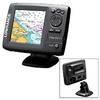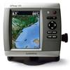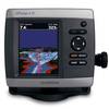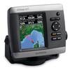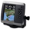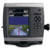
GPSMAP® 547xs
Model: 547xs Brand: Garmin
An Amazing Chartplotter/Sounder Combo
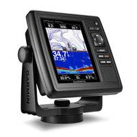
5" VGA display
10Hz GPS/GLONASS receiver
HD-IDâ 1E¢ sonar
Wireless connectivity
U.S. coastal and inland mapping
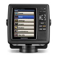
GPSMAP 547xs combination chartplotter/sounder allows for easy visibility, day or night. Whether it is flat, flush or swivel-mounted, it will be the focal point of your helm. It includes our hallmark user-friendly interface as well as U.S. coastal and inland mapping.
Super-fast 10 Hz GPS/GLONASS
With the integration of a 10Hz GPS/GLONASS receiver, the 547xs refreshes position and heading up to 10 times per second. It displays constant and fluid on-screen location and proves to be incredibly accurate when marking waypoints and navigating.
Advanced Echo HD-ID Sonar
In addition to the integrated receiver, GPSMAP 547xs also allows for sonar recording. This feature coordinates the timing of the sonar return in relation to the boatâ AC!22s position â AC 1D so every one of the available 5,000 waypoints will be accurate and precise. It's an absolute must when locating and pinpointing the next hot fishing spot.
Spread-Spectrum CHIRP Sonar
When used with a compatible CHIRP transducer (sold separately), GPSMAP 547xs displays crystal-clear sonar images to help find the next hidden fishing spot, ship wreckage or diving location. With our Spread-Spectrum technology, you can see target separation and resolution at extraordinary depths, and dial into specific frequencies to target certain species of sport fish. Bottom contours are more visible, and signal noise can be suppressed at greater depths to provide a more timely interpretation of whatâ AC!22s below for safer navigation and better fishing.
Product Specification
-
Physical & Performance
Unit dimensions, WxHxD: 5.9" x 6.1" x 2.4" (15.0 x 15.5 x 6.1 cm)Display size, WxH: 3.0" x 4.0", 5.0" diagonal (7.6 x 10.2 cm, 12.7 cm diagonal)Display resolution, WxH: 480 x 640 pixelsDisplay Type: VGA displayWeight: 1.7 lb (0.8 kg)Waterproof: Yes (IPX7) -
Maps & Memory
Basemap: YesAbility to add maps: Yes (via microSD card)Accepts Data Cards: dual microSD!22 card slotsWaypoints/favorites/locations: 5,000Routes: 100 -
Features & Benefits
CANet® compatible: NoSupports AIS (tracks target ships' position): YesSupports DSC (displays position data from DSC capable VHF radio): YesAudible alarms: YesTide tables: YesSun and moon information: Yes3-D map view: Yes (with optional BlueChart g2 Vision card)Dual-frequency sonar capable: YesDual-beam sonar capable: YesSplit-screen zoom: YesSplit-screen sonar/gps: YesUltrascroll® (displays fish targets at higher boat speeds): YesSee-thru® technology (exposes fish hidden in cover): YesFish Symbol ID (helps identify fish targets): YesAutoGain Technology (minimizes clutter, maximizes targets): YesWhiteline (indicates hard or soft bottom): YesAdjustable depth line (measures depth of underwater objects): YesA-scope (real time display of fish passing through transducer beam): YesBottom lock (shows return from the bottom up): YesWater temperature log and graph: YesWater temperature sensor included: Yes -
Other Specs
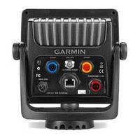
Frequency: 40 kHz-210 kHzTransmit Power: 1 kW (600W CHIRP)Voltage range: 10V-32V inputMaximum Depth: 2,000 ft salt water (depth capacity is dependent on water bottom type and other water conditions)Additional: Wireless connectivity: yesHD-ID tracking technology: yesSonar recording: yesConnects to a compatible Fusion media system: noBluetooth® wireless technology: yes
Related Products
-
EXPLORER PLUS C-MAP MAX/NT+Charting System Control Unit
-
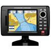
CP190i 5" ChartPlotter
-
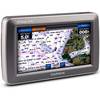
GPSMAP� 640 Marine & Automotive GPS, North America
-
Elite-5m Chartplotter
-
GPSMAP 620 World Wide
-
GPSMAP 526 Chartplotter
-
Chartplotter 431s with Dual-beam Transducer
-
GPSMAP 421 Chartplotter
-
GPSMAP 521 Chartplotter, 5"
-
GPSMAP 531 Chartplotter, 5"
-
GPSMAP 742 Chartplotter
-
TRAWL PLOT 12SD 12.1" Color LCD 16 Ch. GPS/WAAS Charting System