010-C0728-10 Bluechart G2 HUS027RHawaiian Islands Mariana
Model: 010-C0728-10 Brand: Garmin
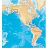
Coverage of the Pacific Ocean from the Hawaiian to Mariana Islands. Includes coverage of Guam, Midway, and Johnston Atoll. General coverage of Palmyra Atoll and the Marshall Islands also included. See your surroundings more clearly with BlueChart g2 data. With BlueChart g2, you'll get detailed marine cartography that provides convenient viewing of nautical content. BlueChart g2 allows you to see your vessel's precise, on-chart position in relation to naviads, coastal features, anchorages, obstructions, waterways, restricted areas and more. You will also have access to detailed mapping capabilities that include Safety Shading , Fishing Charts , smooth data transition between zoom levels, harmonious transition across chart borders, and reduction of chart discontinuities. « less
Product Specification
-
Universal Product Identifiers
Part Numbers: 010-C0728-10, 10469849, 35558, GAR010C072810GTIN: 00753759089290
Related Products
-
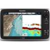
T70035 C127 Multifunction Display w/Sonar - Row Charts
-
37673 Platinum Plus South Alaska on SD Micro SD
-
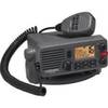
Lvr-250 DSC VHF Fixed-Mount Marine Radio
-
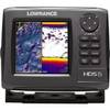
HDS-5 Gen2 Lake Insight with 83/200 kHz Transducer 000-10515-001 42968
-
Adjustable Tilting Wall Mount Bracket for LCD LED Plasma (Max 165Lbs, 52~71inch) - Extra Wide - Silver
-
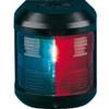
Navigation Light for Bulk Head Mounting , Stern
-
Bulk cable - CAT 6 - 1000 ft - Black
-
USB 3.0 | Extension Cable | 10ft | Type A | Male/Female | Black
-
lian I-Series Dish Network HD Receiver DISH211K
-
TC44224 Tow Vehicle Side Connector
-
TNC-Cp/Gs-02 Connector for RG-8X Cable tncpgs
-
MPI 480-6000 6 in. Insulated Air Conditioner Duct