010-C0751-10 Bluechart G2 HAF451SNamibia to Knysna Sa Data
Model: 010-C0751-10 Brand: Garmin
Coverage of the southwestern coast of Africa from Cape Ponta-Grossa in Angola through Knysa, S. Including detailed coverage of Walvis Bay, Nam., as well as Port Nolloth, Hondelklipbaais, and Cape Town, S. Detailed coverage also includes the island of St. Helena, the Tristan da Cunha Group, and Gough Island. See your surroundings more clearly with BlueChart g2 data. With BlueChart g2, you'll get detailed marine cartography that provides convenient viewing of nautical content. BlueChart g2 allows you to see your vessel's precise, on-chart position in relation to naviads, coastal features, anchorages, obstructions, waterways, restricted areas and more. You will also have access to detailed mapping capabilities that include Safety Shading , Fishing Charts , smooth data transition between zoom levels, harmonious transition across chart borders, and reduction of chart discontinuities. « less
Product Specification
-
Universal Product Identifiers
Part Numbers: 010-C0751-10, 10804623, 35583GTIN: 00753759089719
Related Products
-
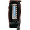
Showdown 5.6 Digital Fishfinder
-
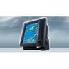
Radar 5215 Package with GMR18 4KW Radome
-
FR8122 12.1 Inch 12KW 72 NM Radar with 4' Open Array Antenna
-
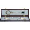
319 Elegant Navigation Set
-
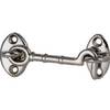
Cabin Door Hook, Bronze, 1-1/2"
-
All Around Light, Clear Nav Light Fresnel Lens Scotty
-
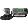
E43034 - Ray49 Class D Ultra Compact VHF
-
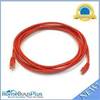
10ft 24AWG Cat6 550mhz UTP Ethernet Bare Copper Network Cable - Red
-
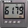
SST110 Surface Temp with Out Sensor
-
/ Quicksilver 22-860382 Connector Speedo
-
Marina Micro LED Hub
-
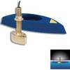
B45-DT-10N 600W Thru-Hull Transducer Northstar 10-Pin Connector