010-C0759-10 Bluechart G2 HAW451SRed Sea Data Card
Model: 010-C0759-10 Brand: Garmin
HAW451S Covers: Coverage of the Red Sea and Gulf of Aden in their entirety, as well as the Indian Ocean including portions of the coasts of Somalia and Oman. Also includes coverage of the Mediterranean Sea from Beirut, Leb. to Alexandria Egy., including the Suez Canal and Gulf of Aqaba. Included in this overall general coverage are numerous detailed charts covering areas such as Jiddah, Sau., Djibouti, Dji., and Aden, Yem. « less
Product Specification
-
Universal Product Identifiers
Part Numbers: 010-C0759-10, 10804722, 35591GTIN: 00753759091415
Related Products
-
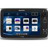
T70057 E127 Multifunction Display w/Sonar - US Inland Charts
-
T70047 E97 Multifunction Display w/Sonar - US Inland Charts
-
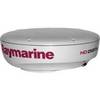
T92183 RD418HD 4KW 18 Inch HD Dome with Cable
-
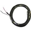
15m Power/Marine Radar Network Cable 320-00206-00
-
Package(C120W, DSM300G Sounder, RA1072HD 4KW 72 Inch HD Digital Open Array Radar & 15m Radar Cable)
-
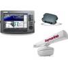
Package(c127 with USA Coastal Chart, 4KW 24 Inch Digital Radome & Radar Cable)
-
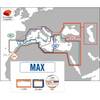
Max EM-M917 MW1 Mediterranean-Black Sea-MAX
-
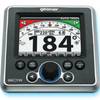
GSC Autopilot No Rudder Feed Back or Drive 700048-1
-
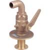
0834006PLB Seacock w/Curved TP 1in
-
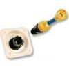
31910-1200 Quick Release Pressure Regulator W Adapter
-
1852061 MKR-US2-1 Garmin Adapter Cable
-
VHF255Sw White VHF Radio