010-C1025-20 Bluechart G2 HXEU718LMediterranean Sea Microsd/sd
Model: 010-C1025-20 Brand: Garmin
See your surroundings more clearly with BlueChart g2 data. With BlueChart g2, you’ll get detailed marine cartography that provides convenient viewing of nautical content. BlueChart g2 allows you to see your vessel’s precise, on-chart position in relation to naviads, coastal features, anchorages, obstructions, waterways, restricted areas and more. You will also have access to detailed mapping capabilities that include Safety Shading, Fishing Charts, smooth data transition between zoom levels, harmonious transition across chart borders, and reduction of chart discontinuities. Covers: Detailed offshore coastal coverage of the Mediterranean Sea in its entirety. Coverage features the Strait of Gibraltar, the Balearic Islands, the French Riviera, Corsica, Sardinia, Sicily, the Adriatic Sea, the Greek Islands, the Aegean Sea, the Dardanelles and Bosporus Straits, the Sea of Marmara, Cyprus, the Suez Canal, Tripoli and Algiers Harbors, and the Gulfs of Gab « less
Product Specification
-
Universal Product Identifiers
Part Numbers: 010-C1025-20, 10807295, 35822GTIN: 00753759096250
Related Products
-
408710-1 958c HD Di Combo
-
SP36-12 Autopilot Virtual Feedback 30CI Pumpset
-
2000 Series Tank Mount Instrument Replacement - 4-1/2 Inch Speedometer/Tachometer with Direct ECM Plug-in for Harley Davidson Road King 2004-2012 / Softail 2004-2010 - Red - MCL-2004-R
-
SP110RF-1 SP-110 System w/Rudder Feedback & No Drive Unit
-
AIT2000 Class B Transponder Wgps Antenna Includes Prog
-
Navigation Light Masthead
-
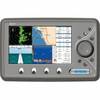
EC7IF Chartplotter w/Internal Antenna & Fishfinder Tan / Red
-
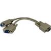
04-1092-000R Standard VGA Cable Splitter
-
35ft Premium Optical Toslink Cable w/ Metal Fancy Connector
-
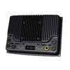
000-10290-001 - NSO System, Processor Only
-
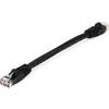
Black Six Inch Category 5 Enhanced Cat 5e Ethernet Network Cable .5
-
Wiring Device-Kellems Hbl61cm54 Marine Adapter 3d968