4123 La &Amp; Orange County Inshore
Model: 4123 Brand: Fish-n-Map
FISH-N-MAP UNDERWATER TOPOGRAPHY MAPSMade of waterproof, tear resistant plastic. Features include: underwater depth contours, fish locations, latitude and longitude for GPS, multiple freshwater lakes on one map, boat ramps, recreational facilities and much more.
Product Specification
-
Universal Product Identifiers
Part Number: 4123GTIN: 00761428041234
Related Products
-
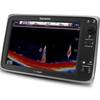
E127 Multifunction 12" Display with Sonar - US Inland Charts T70057 c44354
-
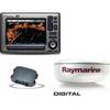
Package(E90W, GPS Antenna, DSM300G Sounder, 4KW 18 Inch Digital Radome & Radar Cable )
-
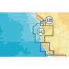
BlueChart g2 Vision - Italy, Adriatic Sea - Maps
-
MSD/643P+ Platinum Plus Oregon & California - SD/Micro SD
-
Popular Atlases, Gulf Islands Atlas Canadian Charts
-
Cat6a Ethernet Cable | 5ft | Orange | Network | 10 Gigabit
-
1ft 24AWG CL2 High Speed HDMI Cable w/ Net Jacket - Black
-
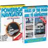
Video SNAV DVD Navigation Set W Powerboat
-
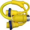
LTD A3030Y50 50 Amp to 30 Amp Y Adapter
-
18-8804-1 Premium Marine Spark Plug Wire Leads
-
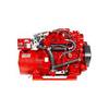
12.5 Sbeg Generator
-
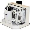
FCF-12000 Feel Cool Fast Marine Air Conditioner by Webasto