4125 Map -San Diego/Ensenada
Model: 4125 Brand: Fish-n-Map
FISH-N-MAP UNDERWATER TOPOGRAPHY MAPSMade of waterproof, tear resistant plastic. Features include: underwater depth contours, fish locations, latitude and longitude for GPS, multiple freshwater lakes on one map, boat ramps, recreational facilities and much more.
Product Specification
-
Universal Product Identifiers
Part Numbers: 4125, 7101066GTIN: 00761428041258
Related Products
-
T908 Active GPS Sensor
-
LX-5 Dual Beam True Color Sonar Flasher System
-
1100 Series 1197c SI Combo - Marine Chartplotter - 10.4" color - 800 x 600
-
Classic Stern Light Black, Series 25 25500-7
-
10ft 22AWG 5-rca Component Video/audio Coaxial Cable (RG-59/U) - Black
-
10/3 30 Amp Cable, 250' Spool, Yellow 14179
-
Cat6a Ethernet Cable | 3ft | White | Network | 10 Gigabit
-
Marine Products Plug Wire Set 9-28012
-
MRHH325VP VHF Two-way radio
-
15.0 Beg Generator
-
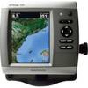
GPSMAP 526 - Marine Chartplotter - 5" color - 480 x 640
-
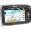
T70002 E7 7" Multifunction Display - Internal GPS, Row