5209; Map-Roosevelt Lake
Model: 5209 Brand: Fish-n-Map
FISH-N-MAP UNDERWATER TOPOGRAPHY MAPSMade of waterproof, tear resistant plastic. Features include: underwater depth contours, fish locations, latitude and longitude for GPS, multiple freshwater lakes on one map, boat ramps, recreational facilities and much more.
Product Specification
-
Universal Product Identifiers
Part Numbers: 250137, 5209GTIN: 00761428052094
Related Products
-
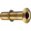
2" Ex-Long Thru-Hull 348-9
-
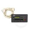
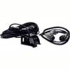
10' Network Cable for Scp Remote Panel 809-0938
-
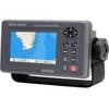
GPS 95CPI GPS Plotter with Internal Antenna c31313
-
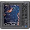
1935 4KW 3.5 Open Array Color LCD Radar 37418
-
BlueChart g2 Vision - Italy, Adriatic Sea - Maps
-
010-C0878-20 Bluechart G2 HXAE003RTaiwan Microsd/sd Adaptor
-
The Nautical Chart: A Novel of Adventure [Book]
-
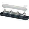
2303 Busbar 4x1/4in Stud Common Bu
-
99-70 SP-X Speed Probe X-seriex Connector
-
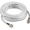
010-11454-00 GPS Antenna Cable w/BNC Connectors - 10M
-
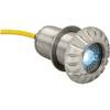
0176DP3CHR LED Thru-Hull Mount Underwater Light - Chrome Plated
-
8027 AC Main + 6 Positions