8267; Map-Lake Oroville/San Luis
Model: 8267 Brand: Fish-n-Map
FISH-N-MAP UNDERWATER TOPOGRAPHY MAPSMade of waterproof, tear resistant plastic. Features include: underwater depth contours, fish locations, latitude and longitude for GPS, multiple freshwater lakes on one map, boat ramps, recreational facilities and much more.
Product Specification
-
Universal Product Identifiers
Part Numbers: 082671, 234800, 432450, 8267, MSI432450GTIN: 00761428082671
Related Products
-
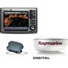
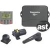
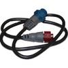
Package(E90W, GPS Antenna, DSM300G Sounder, 4KW 24 Inch Digital Radome & Radar Cable )
-
U1-200B-00A SE-200B Sonar TM 90 Degree Both Vert/Horiz w/2
-
NA-C702 C-Card Format Nanoose - Victoria Cap
-
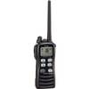
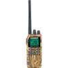
M72-11 Hand Held VHF w/Built in Scrambler
-
Auto Pilot S1g/St8001 Inboard E12121
-
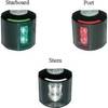
Series 43 White LED Navigation Light Stern
-
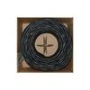
Bulk cable - CAT 6 - Unshielded twisted pair (UTP) 1000 ft - Black
-
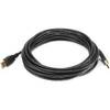
15ft USB 2.0 A Male to A Male 28/24AWG Cable (Gold Plated)
-
NAC-FRD2FBL NMEA Network Adapter Cable 127-05
-
Inc ETS0131472 Computer Hardware
-
VHF55sc VHF Two-way radio
-
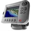
E62190-US - A70 6.4 Chartplotter, US Maps, Int GPS