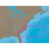
BlueChart g2 Vision - North Maine - Maps
Model: Brand: Garmin
BlueChart g2 Vision offers the same rich detailed charting of BlueChart g2 to help you get the most out of your unit. In addition, g2 Vision features a growing database of high-resolution satellite imagery, above and below the water 3D perspective, auto guidance technology, aerial photographs for real world reference and coastal roads with points of interest. From Calais to Camden, including Bar Harbor and Penobscot Bay. « less
Product Specification
-
General
Product Type: MapsDistribution Media: SD Memory CardFirst Seen On Google Shopping: May 2007 -
Compatibility Information
Designed For: Garmin GPSMAP 4008, 4012, 420, 4208, 420s, 4212, 430, 430s, 430sx, 430x, 440, 440s, 440sx, 440x, 450, 5008, 5012, 520, 5208, 520s, 5212, 525, 525s, 530, 530s, 535, 535s, 540, 540s, 545, 545s, 550, 550s, 555, 555s -
Universal Product Identifiers
Part Numbers: 010-C0702-00, North MaineGTIN: 00753759068820, 00957696612775
Related Products
-
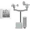
NG Weather 265NNC Touch Screen Weather Station
-
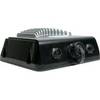
GSD 22 - GPS receiver remote sonar sensor
-
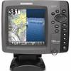
788ci HD Di Combo Down Imaging Combo 39704
-
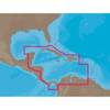
NA-C502 Furuno FP Format Western Caribbean S
-
NA-C304 C-Card Format Norfolk Bermuda Jacksonuville
-
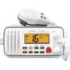
M412 11 Fixed-Mount 25W VHF Marine Radio with Class D DSC (b
-
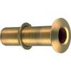
1-1/4 in. Ex-Long Thru-Hull Connection
-
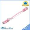
0.5ft 24AWG Cat5e 350MHz UTP Bare Copper Ethernet Network Cable - Pink
-
100ft 16AWG CL2 Rated 2-Conductor Loud Speaker Cable (for In-Wall Installation)
-
50ft VGA to 3 RCA Component Video Cable (HD15 - 3-rca)
-
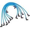
Marine Products Plug Wire Set 9-28020
-
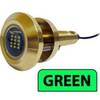
Lumishore Thru Hull Flush Fit 36 Watt Green Underwater Light 41684