ChartKit Book w/Companion CD - Florida East Coast & Map
Model: Brand: Maptech
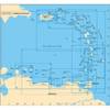
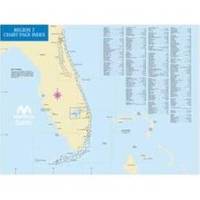
Mary's Entrance to Dry Tortugas, inside and outside, including St. Johns River, St. Lucie River and Lake Okeechobee. Full-color charts, waypoints, courses and distances, chart datums for GPS, Yeoman points, and aerial photos. 22 X 17, 78 chart pages. Product Overview Used by generations of boaters, ChartKits are full-color reproductions of U.S. government and private charts spiral bound into popular cruising regions. The convenient-sized books are large enough to allow for manual plotting, yet small enough to sit on your nav-station or lap GPS Ready New features make ChartKits easy to use with your GPS. Most charts include one-minute lat./long. Grids to make vessel positioning a breeze, and major navigation aids are identified with named GPS waypoints. Small and Large Scale Charts ChartKits include small-scale, wide « less
Product Specification
-
Universal Product Identifiers
Part Number: PAPREGION07
Related Products
-
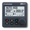
Autopilot Second Station
-
A241 Imray St. Barthelemy Marine Nautical Chart
-
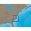
NA-C310 Furuno FP Format - Cape May - Winyah Bay
-
Baynes Sound Chart
-
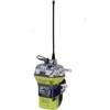
2848 Globalfix iPro Cat II EPIRB with GPS (Manual Activation)
-
Marinenav Barracuda 1.5 Marine Navigation PC Computer BAR-151
-
AP2404 Autopilot System 32210
-
Cat6a Ethernet Cable | 7ft | Yellow | Network | 10 Gigabit
-
Black Six Inch Category 5 Enhanced Cat 5e Ethernet Network Cable .5
-
10ft DB 9 F/F Molded Cable
-
Quicksilver 802182A 1 Connector Pnla
-
TNCM-8-G TNC Type Male Connector for RG-8X Coax