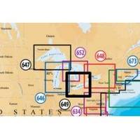
Inc MSD/649P Map, Lake Erie & Saint Clair
Model: 649P Brand: Navionics
Navionics 649P+ Lake Ontario Platinum+ Multi-Dimensional Charts, with the most advanced technology and best imaging available, provide high-resolution photo/chart overlay, full-view XGA panoramic pictures, improved 3D view, complete geo-referenced coast pilots. Compatibility Guide
Product Specification
-
Universal Product Identifiers
Part Numbers: 11093846, 37652, 649P+, DEF-257881MSD649, MSD-649P-, MSD649P+, SD649P, SD/649P+GTIN: '82124564959, 00821245649591
Related Products
-
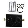
010-11201-00 Autopilot Unbalanced Valve Kit
-
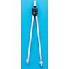
611 Marine Navigation Compass Nickel 7-inch
-
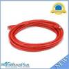
14ft 24AWG Cat5e 350MHz UTP Bare Copper Ethernet Network Cable - Red
-
500ft 14AWG CL2 Rated 2-Conductor Loud Speaker Cable (for In-Wall Installation)
-
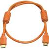
3ft 28AWG High Speed HDMI Cable w/Ferrite cores - Orange
-
36inch SATA 6Gbps Cable w/Locking Latch - UV Blue
-
1.5ft 28AWG High Speed HDMI Cable w/Ferrite cores - Green
-
Ethernet Category 5 Enhanced RJ45 Network Patch Cable - 3'
-
Wiring Device-Kellems Hbl64cm59 Marine Y Adapter 3d988
-
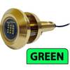
Lumishore THX36-G Thru-Hull Flush Fit Underwater Light - Green 36W
-
5.5 BCD Diesel Generator
-
E62115-US - C140Wide 14 MFD, US Charts, Int GPS