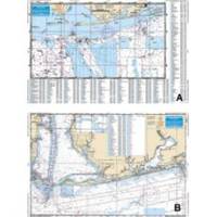
Mobile Bay to Pensacola Offshore Fishing - Waterproof Charts
Designed for recreational boaters, fishermen and divers. Waterproof Charts are beautifully printed on synthetic paper. For use on deck in any weather rain or spray! Accurate, used by Coast Guard and Navy, simple to use with GPS. Foldable and easy to hold and store Waterproof Charts are so tear resistant you can't ruin them. Printed on both sides so they save you money! Offshore coverage from Dauphin Island, Alabama to Pensacola Beach Florida out 30 plus miles. This chart is a compilation of 3 NOAA charts # 11360, 11376 and 11382. This chart goes up into MOBILE BAY over 21 miles, and offshore over 30 miles. From Daupin Island the chart goes over 55 miles to the South. The chart has over 550 plotted and indexed GPS waypoints for wrecks, reefballs, ledges and artificial reefs, fishing and diving locations. The really unique feature to this Offshore Fishing Chart is that it is LARGE PRINT!!! Meaning it is much easier to see the coordinates of your favorite fishing destination. No one has a chart like this. If you want ORANGE BEACH , Alabama, you want this chart. « less
Product Specification
-
Universal Product Identifiers
Part Number: 94F
Related Products
-
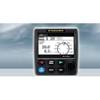
NAVPILOT 711 Autopilot for Inboard without Pumpset
-
Video SBELE3DVD DVD Boaters Guide to Radar GPS
-
GMR 24 4KW Digital Radar Scanner
-
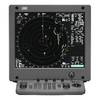
JMA-5312-6 Radar 96 NM with 6' Open Array & 19 Inch LCD Monitor
-
Package(C120W, DSM300G Sounder, RA1048D 4KW 48 Inch HD Digital Open Array Radar & 15m Radar Cable)
-
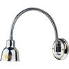
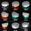
Marine Lighting, LED, Bulkhead Mount, Ocean Chart Lamp, 10 - 30V DC, Medium, Stainless Steel Finish, Warm
-
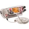
GB0869 VHF Marine Large Screen Radio
-
200-018 - 2*180 Degree Green - LED Navigation Light
-
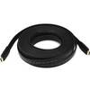
4163 30ft 24AWG CL2 Flat Standard HDMI Cable - Black
-
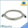
9 Pin/ 6pin Bilingual FireWire 800 - FireWire 400 Cable, 6ft, Clear
-
408890-1 898c HD Si Combo
-
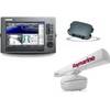
GPSMAP 421 - Marine Chartplotter - 4" color - 240 x 320