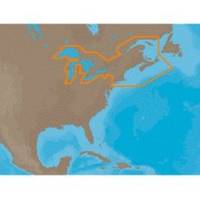
NA-M026 C-Card Format Great Lakes and The Maritimes
Model: NA-M026 Brand: C-Map
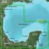
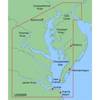
NA-M026 => Great Lakes, Northeast Coast and ApproachesCoverage of the Great Lakes, St. Lawrence River and Northeast United States. Coverage of the Great Lakes also includes Fox River and Lake Winnebago, Lake St. Clair, Rideau Canal, Ottawa River and the Trent-Severn Waterway. Includes all coastal charts for New Brunswick and Nova Scotia in Canada and Maine, New Hampshire, Massachusetts, Connecticut and New York in the U.S. Also included is coverage of the Hudson River and Lake Champlain as well as the Erie Barge Canal. Specifications:Port Plans: YesAerial Photos: Yes3-D View: Yes « less
Product Specification
-
Universal Product Identifiers
Part Numbers: 30127, NA-M026, NA-M026C-CARDGTIN: 000000165840, 00686074002791
Related Products
-
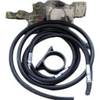
010-11202-00 Autopilot VeradoAdapter Kit
-
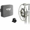
E12133 SmartPilot X-5 Wheel Corepack (No Control Head)
-
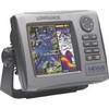
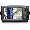
99-001 Hds5i-bndl, Hds-5, Fishfinder
-
BlueChart g2 Vision - Southern Gulf of Mexico - Maps
-
MapSource BlueChart - Chesapeake - Maps
-
CF/637P+ NJ & Deleware Plat+ on CF
-
93881 ACR GPS Interface Cable for 2874 Sat 3 EPIRB
-
AP2803VRF Autopilot AP28,AC12,RC42,RPU80 32221
-
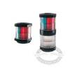
Marine 002984535 Series 2984 Navigation Lamp Tri Color Light
-
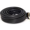
560 VGA + 3.5mm Stereo Audio Male to Male Cable 50 ft. CL2
-
/ Quicksilver 864182T Connector Pnla
-
998c Si Combo Cho Display Only #407760-1CHO