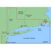
NT+ Wide Chart (americas) c11206
Model: c11206 Brand: C-Map
NT+ C-card technology is reverse-compatible with current NT charting systems. Full benefits of improved chart display are optimized on systems Designed for NT+ (or by updating your NT system software to NT+). Vastly Expanded Coverage: Important advances in technology now permit C-MAP to offer significantly increased coverage areas without sacrificing compatibility or performance with current C-card based navigating systems. This has, in turn, resulted in much more coverage at a much lower cost! Extra Information Not Found On Official Government Charts: True Color NavAids - Extensive NavAid information, allowing for on-screen display in true shapes and colors. Port Info - Complete and detailed databases of port facilities, services and contact information. Tide Info - NT+ C-cards include primary and secondary tidal stations that can be queried for easy access while navigating. Easy-to-read graphs display depth at high and low water for sun-up and sun-down. Tidal predictions make travel planning easier and safer. Improved Chart Display: Paper Chart Appearance - All the advantages of electronic charts with the familiar look of a paper chart. C-MAP's experience with professional navigation and highly effective chart display has resulted in a new chart look for NT+. This new look makes creative use of colors, patterns and icons to increase the familiarity and usability of the content-rich NT+ database. New NavAid Symbols and Styles - Depending upon navigation situations and mariner's preference, Aids to Navigation can now be configured for three basic styles: INTERNATIONAL - NavAids shown in real life shapes and colors for quick visual recognition (as per official paper chart presentations). UNITED STATES - NavAids shown in simplified shapes and real colors (as generally found on NOAA paper charts). SIMPLIFIED - NavAids shown in generic symbols for minimum visual clutter on-screen. SIMPLE - Some selections are turned off, such as Light Sectors, Seabed Type, Tracks & Routes, Lat/Lon Grid. FISHING - Turns off even more selections, like Tides & Currents, Ports & Services, Rivers & Lakes, Chart Boundaries. CUSTOM - The navigator selects which features he'd like on the screen. What are the Differences Between NT+ Local, Wide & SuperWide C-cards? Simply put, the differences lie in the C-cards geographical coverage and pricing. They differ only in the amount of the boating area that the individual NT+ C-card covers. « less
Product Specification
-
Universal Product Identifiers
Part Number: c11206
Related Products
-
Colormax Wide 7 Panoramic LCD w/Internal Antenna
-
CH250BB/60/240 60 kHz Black Box Searchlight Sonar System. Includes 400mm Travel Hoist and Operates at 12VDC
-
740S/GMR24HD GPSMAP 740S Radar Pack w/GMR 24HD
-
PC Planner NT 128KB for Raymarine
-
MapSource BlueChart - New York - Maps
-
Cd-148012 Sea Life Mini Incentive Charts
-
CWP320 Instrument Companion Waypod
-
KCA RC107MR Marine CD receiver remote control unit
-
SP-70L Autopilot f/Outboards & Includes Feedback & Pumps
-
6ft 24AWG CL2 Silver Plated High Speed HDMI Cable - Black
-
Fiber Optic Cable, LC/LC, Multi Mode, Duplex - 1 Meter 6202
-
18 8076 Fuel Connector for Mercury/Mariner Outboard Motors