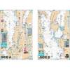
Paper Chart Kit Book REGION03 New York to Nantucket
Model: REGION03 Brand: Maptech
Completely updated. Coastal and offshore coverage. Full-color charts, GPS waypoints, courses and distances, Yeoman points, and color aerial photos. Save hundreds of dollars on charts. 22 X 17, 90 chart pages. Product Overview New features make ChartKits easy to use with your GPS. Most charts include one-minute lat./long. grids to make vessel positioning a breeze, and major navigation aids are identified with named GPS waypoints. GPS Ready New features make ChartKits easy to use with your GPS. Most charts include one-minute lat./long. grids to make vessel positioning a breeze, and major navigation aids are identified with named GPS waypoints. Small and Large Scale Charts ChartKits include small-scale, wide area charts as well as large-scale, detailed charts of harbors and approaches. « less
Product Specification
-
Universal Product Identifiers
Part Number: PAPREGION03
Related Products
-
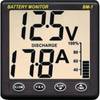
BM-1 Battery Monitor Instrument
-
NA-C703 Furuno FP Format Cape CAUTION - Portland Canal
-
EM-C102 Furuno FP Format - Black Sea & Marmara
-
Lake Champlain Fishing South - Waterproof Charts
-
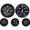
KT9796 Euro 4-Gauge Set (Speed Tach Fuel Volt)
-
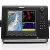
NSE8 Navigation Pack - NSE8, GS15 & BR24
-
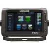
00010771001 HDS-9 Touch G2 Insight 83/200
-
25ft 24AWG Cat6 500mhz Crossover Ethernet Bare Copper Network Cable - Gray
-
5ft 24AWG Cat5e 350MHz UTP Bare Copper Ethernet Network Cable - Pink
-
010-10922-00 Power Cable 2 Pin for 5000 Series
-
3ft 32AWG Mini DisplayPort Male to Female Extension Cable - White
-
Ram 1" Connector - TM00506