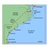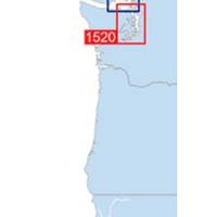
Waterproof Chart Kit - Puget Sound #WPB1520-02
Model: WPB1520-02 Brand: Maptech
Waterproof Charts w/ Companion CD WPB1520 1520: Puget Sound Covers the entire sound from Olympia to Admiralty Inlet, including Lake Washington. 25 pages of charts, 150 GPS waypoints, Lat. /Long. grids, courses, ramps, and 180 marine facilities. Overview and detailed charts. 12 x 17, scales 1:225,000 to 1:13,000. Product Overview These easy-to-use, compact chart books are ideal for Day-Sailors, Fishing Boats, and Trailer Boats. They measure 12 x 17 (24 x 17 when open) and are made of waterproof, tear-resistant synthetic paper that will withstand the elements. GPS Ready New features make Waterproof Chartbooks easy to use with your GPS. Most charts include one-minute lat./long. grids to make vessel positioning a breeze, and major navigation aids are identified with named GPS waypoints. Small and Large-Scale Charts Waterproof Chartbooks include small-scale, wide area charts as well as large-scale, d « less
Product Specification
-
Universal Product Identifiers
Part Number: WPB1520-02
Related Products
-
LX-7 Color LCD Sonar
-
C97 Multifunction 9" Display with Sonar - European Charts T70023 c44025
-
Radar 4012 Package with GMR24HD 4KW Radome & GSD22 Sounder
-
MapSource BlueChart - Carolinas - Maps
-
5ft 24AWG Cat5e 350MHz UTP Bare Copper Ethernet Network Cable - Yellow
-
644 6ft 3.5mm Stereo Plug/Plug M/M Cable - Black
-
SST110 Surface Temp with Out Sensor
-
Phone Cable, RJ11 (6p4c), Reverse - 7ft for voice
-
Hook & Loop Fastening Cable Ties 6inch, 10pcs/Pack - Blue
-
YQ100PLUS - Adapter Cord Set, 125/250V, Yellow
-
Connector Kit for 3/8 Inch LED Rope Light - Imt-ilmdl-con24v-l6
-
n�vi 2350 - Automotive GPS receiver - 4.3" color - 480 x 272 - widescreen