End-users trialing the VoyOpt voyage optimization service say it beats the competition in terms of the number of data sources it aggregates, ease of use and bottom-line benefits.
Fuel consumption is the leading cost driver in shipping and remains the top fiscal concern of shipowners amid uncertainty surrounding bunker costs and availability. “Managing fuel consumption effectively means owners need increasingly to adopt new performance tools that leverage cutting-edge technology, including artificial intelligence. That’s exactly what we offer with VoyOpt,” says VoyOpt Marine Application Director Sverre Dokken.
“As an automated, all-weather voyage planning service VoyOpt provides owners and crew with superior voyage optimization to improve not only fuel efficiency but also reduce emissions without compromising transit time, which is a key component for operators in a fiercely competitive business,” Dokken says.
High reliability
The system calculates more variables critical to vessel performance than any competing system, including local weather forecasts, ocean currents and wave dynamics, wind data, ship performance models, navigational information, and environmental regulations. “Optimal leveraging of weather data is critical. Weather predictions typically lack long-term reliability. Using combined forecasting model predictions gives higher forecast reliability than route planning based on weather forecasting alone,” says Dokken.
The best route by far
VoyOpt selects the most secure forecast using Earth Observation (EO) and satellite data, probability algorithms, seasonal data, current weather, and climatology. LNG carrier captain Jørgen Grindevoll says he has grown to appreciate its ability to deliver the most reliable weather prediction – or “the one that is most likely to be correct” – putting VoyOpt ahead of the game in the performance space.
Fellow trial end-user Capt. Pär Brandholm, senior performance and technical manager with a well-known chemical tanker owner, says VoyOpt offers more granularity in terms of blue-water voyages. “For longer voyages we normally get a broad recommendation, or a few steps, from the services we’ve been using for many years. VoyOpt is much more specific,” he says.
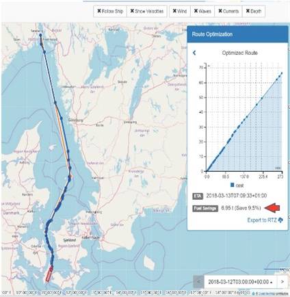 Shortsea (coastal) VoyOpt display showing route from Oslo to Kiel (Image: VoyOpt)
Data aggregation ‘breakthrough’
“For me the biggest breakthrough is how VoyOpt aggregates weather data from multiple global systems and local forecasts, including hydrographical data and satellite data on wave height, winds and currents. Competing solutions use one global model, but VoyOpt uses AI to crunch these data streams into one, much more reliable forecast,” adds Brandholm.
In Capt. Brandholm’s fleet, 13 vessels are connected to the system and live testing continues. “The tech guys at VoyOpt have done an amazing job with the ship models, which you can see on the map and they reflect the actual fuel consumption,” Brandholm says.
VoyOpt calculates voyage plans based on optimal engine power and speed, significantly lowering fuel burn and emissions while enabling highly accurate arrival time estimates (ETAs). “The navigation officer enters a destination, and VoyOpt incorporates these factors to propose an optimised route,” says Grindevoll, adding that route display features in the graphical user interface (GUI) allows fuel savings to be monitored in real time.
“My basis of comparison is 20 years’ experience with other systems,” says Grindevoll. “Either they were optimized for open ocean sailing only, used only a single weather forecast, or looked only at wind predictions, when in fact currents affect the hull more than wind. The key differentiator with VoyOpt is the advanced route optimization function.”
Superior usability
“VoyOpt is intuitive and very easy to use,” says Brandholm. “The GUI is excellent and the system responds very quickly. You also don’t need a huge book of instructions. Any captain or bridge officer will understand it pretty much immediately. For me it scores very high on usability – and I have a lot of experience in performance and weather routing systems. VoyOpt also gives the captain the ability to import the route, which he can use directly on the bridge.”
Short-sea ‘game-changer’
Coastal and short-sea trades make up 90% of all shipping in Europe. “The majority of navigators on these routes choose to sail in a straight line, without consideration of waves, wind or currents,” says Dokken. VoyOpt considers all these parameters and dynamically calculates optimized routes to provide higher fuel efficiency. “This is unique in the market today,” says Dokken.
“When it is commercially launched in a few months’ time, I am confident VoyOpt will be a game-changer in short-sea. To my knowledge, there are no suppliers of weather routing for voyages of less than three or four days,” says Brandholm.
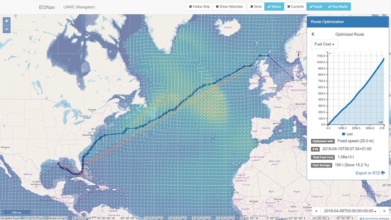
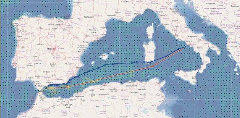 VoyOpt display showing optimized route between Spain and Italy (Image: VoyOpt)
Boosting the bottom line
“Maximizing the positive effects of currents has been very useful for our ships sailing in the Gulf of Mexico. Using VoyOpt we have seen a reduction in fuel consumption from a few percent to 7% or 8%, as well faster transit times due to optimal routing. The lowest fuel consumption on the quickest route of course has direct financial benefits,” says Brandholm. “I am sure other owners will experience the same benefits.”
Addressing the pain points
Dokken underscores how extensive collaboration with end-users helped to refine VoyOpt, with thorough validation studies demonstrating fuel and emissions savings. “The industry pain points we want to help shipowners address with VoyOpt are sustainability, safety and solvency, in response to environmental, performance and financial pressures,” Dokken says. “With a 24/7 web-based service providing real-time local weather observations and continuous route updates, VoyOpt can help them to reach these goals.”