Photo: UKHO

UKHO Creates High Density ENC of the Bristol Channel

|

The United Kingdom Hydrographic Office (UKHO) has disclosed details of a new Electronic Navigational Chart (ENC) which could help to improve situational awareness and safety.
 
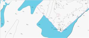
Developed to cover an area of the Bristol Channel known as ‘The Bridge’, this ‘high density’ ENC displays depth contours at one-meter intervals, allowing ECDIS to set safety contours at corresponding levels to support navigation through shallow water.
 
ECDIS will select safety contours based on a safety contour depth value set by the mariner. As most charts contain depth contours at intervals of 2, 5, 10, 20 and 30 meters, ECDIS will sometimes have to set a safety contour at a deeper interval than the value set by the mariner. As a result of this, ships navigating in shallower areas like ‘The Bridge’ have had to cross the safety contour and override ECDIS alarms, as they have more clearance than indicated. Disabling these alarms not only increases administrative burden and alarm fatigue, but also means that alarms will not indicate if the ship is actually approaching depths of insufficient under keel clearance.
 
To overcome this challenge, the UKHO has been working with partners to adapt this ENC to include one-meter depth contours. In addition to safety benefits, this could also bring a significant commercial benefit to cargo owners and ship and port operators, as ships can be more confident about the true depth of water under the keel - thereby increasing ships’ cargo-carrying capacity.
 
To create the ENC, the UKHO worked with the manufacturers of their cartography software to develop a new tool that automatically processes billions of bathymetric data points (that are delivered through highly accurate, multibeam sonar surveys) to draw one-meter contours. These are then confirmed within the software to ensure compliance with strict international standards for all ECDIS systems. Finally, these are manually checked by a cartographer to confirm accuracy.
 
This charted area with high density contours was then issued digitally through the ADMIRALTY Vector Chart Service (AVCS), allowing safety contours at key areas to be drawn by ECDIS with one-meter accuracy. This helps to reduce stress on the bridge and can give crews a greater degree of confidence on the approach for the safety of cargo and ship.
 
Chris Berkley, a Master Mariner and Product Manager at UKHO, commented: “Marking depth contours at five-meter intervals made complete sense when it was being drawn by hand on paper or read off a physical chart by a mariner – one-meter contours can be close together and confusing when applied over wide areas. The advantage of digital navigation on ECDIS is that we can now switch from five-meter contouring to higher density one-metre contouring in areas where it is useful.
 
“During this project, UKHO’s hydrographic database team developed a tool that fits into our business-as-usual charting methods to create an ENC for a geographic feature called ‘The Bridge’ in the Bristol Channel and Severn Estuary. In this location, silt collects to form an area of water that is far shallower than the rest of the channel. Ships must pass over ‘The Bridge’ to get to the Ports of Bristol or Gloucester.
 
However, even though most ships can safely transit this area, it is beyond the safety contour for many commercial ships. Effectively, ships entering the Port of Bristol need to knowingly ignore their training and cross the safety contour – setting off multiple alarms, causing lots of disruption, and creating significant paperwork for the master to explain.
 
"With the new and now in-use AVCS ENC for this area, we have solved this problem and masters and pilots can now navigate the area safely and in accordance with the rules on safety contours.”
 
The UKHO is now extending the format to other ports and channels in the UK and around the globe which are experiencing similar challenges, thereby supporting greater navigational safety and efficiency.
 
 
E-News