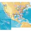
010-C0763-10 Bluechart G2 HEU004RIrish Sea Data Card
Model: 010-C0763-10 Brand: Garmin
British coast: covers from Port Ellen on the Isle of Islay to Falmouth, including the Isle of Man and the Isles of Scilly. Irish coast: covers from Sheep Haven to Caherciveen, Republic of Ireland, including Londonderry, The Storks, Belfast, and Dublin. See your surroundings more clearly with BlueChart g2 data. With BlueChart g2, you'll get detailed marine cartography that provides convenient viewing of nautical content. BlueChart g2 allows you to see your vessel's precise, on-chart position in relation to naviads, coastal features, anchorages, obstructions, waterways, restricted areas and more. You will also have access to detailed mapping capabilities that include Safety Shading , Fishing Charts , smooth data transition between zoom levels, harmonious transition across chart borders, and reduction of chart discontinuities. « less
Product Specification
-
Universal Product Identifiers
Part Numbers: 010-C0763-10, 10804839, 35599GTIN: 00753759091491
Related Products
-
GMR 604 XHD Radar - 4 ft. 6KW Pedestal Array
-
Package(c125 with aus, NZ, S. America, Asia Chart, 4KW 18 Inch Digital Radome & Radar Cable)
-
MSD/647P+ Platinum Plus Lake Superior on SD/MicroSD
-
WPC025; Upper Chesapeake Bay
-
CF/637P+ NJ & Deleware Plat+ on CF
-
B16420Cx 1kW 50200khz 20 Deg Tilted Element
-
Cat6a Ethernet Cable | 15ft | Blue | Network | 10 Gigabit
-
T70007 e7D 7" Multifunction w/Sonar, Internal GPS - Row
-
Hook & Loop Fastening Cable Ties 6inch, 100pcs/Pack - Black
-
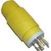
30M1 30 Amp - 125VAC Male Plug
-
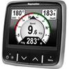
E22172 i70 Multifunction Instrument Display
-
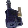
80404 Fuel Connector