290 Marine Navigation ROADrule Marine Navigation Aids
Model: 290 Brand: Weems And Plath
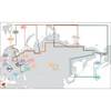
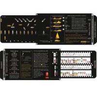
ROADrule USATONS identifies the most common U.S. aids to navigation, rules of the road, and maneuvering and warning signals for U.S. waters. This simple-to-use identification tool shows the actual view of maritime buoyage systems with corresponding chart symbols. It describes bridge lighting and Intracoastal Waterway markings. ROADrule takes a large amount of complex information and makes it easy to understand and quick to refer to. Whether in a classroom or at the helm, critical decisions can be made quickly and with confidence with the aide of ROADrule. Features: Constructed of durable two-sided black PVC. Design is similar to a slide-rule Various buoyage markers are drawn in color to match the chart symbol Stored in a vinyl sleeve and fits nicely in a chart table Dimensions: 16” x 5 ¼”. « less
Product Specification
-
Universal Product Identifiers
Part Numbers: 290, 9234881, DEF-800094GTIN: 00721002004192
Related Products
-
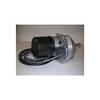
Dashboard Autopilot Drives for Cable Steering 24V 29010004
-
MDS-1 2KW 12 Inch Dome Radar Add-on with 10 Meter Cable wmsd1
-
Max RS-M202 W36 Russian Federation NW-MAX
-
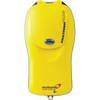
Pains Wessex Fastfind Plus GPS Personal Locator Beacons
-
Marinenav Explorer Marine Navigation PC Computer EXP-013-intel
-
0835005PLB 3/4 Seacock w/Straight Tail
-
3in Plain Bronze Door Hook
-
3ft 32AWG Mini DisplayPort | Thunderbolt to VGA Cable - White
-
25ft 24AWG Cat5e 350MHz UTP Bare Copper Ethernet Network Cable - Gray
-
26CM11 Male Plug for 30 AMP/125 Volt
-
B75-20-M Broadband Chirp 20 Degree Tilt, No CONNECTOR, Depth & Temperature Thru-Hull Tilted
-
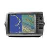
GPSMAP 4012 - Marine GPS receiver - 12.1" color - 1024 x 768