8268; Map-The Delta
Model: 8268 Brand: Fish-n-Map
FISH-N-MAP UNDERWATER TOPOGRAPHY MAPSMade of waterproof, tear resistant plastic. Features include: underwater depth contours, fish locations, latitude and longitude for GPS, multiple freshwater lakes on one map, boat ramps, recreational facilities and much more.
Product Specification
-
Universal Product Identifiers
Part Numbers: 164527, 8268, MSI432492GTIN: 00761428082688
Related Products
-
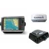
Radar 4208 Package with GMR24HD 4KW Radome & GSD22 Sounder
-
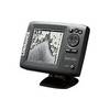
Mark 5x - Fishfinder - included transducer : Skimmer
-
The Nautical Chart [Book]
-
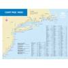
Paper Chart Kit Book REGION03 New York to Nantucket
-
Tech SYADA23026 Computer Hardware
-
Pipe Dk Plt 1.25 PLB - Buck Algonquin
-
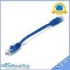
0.5ft 24AWG Cat5e 350MHz UTP Ethernet Bare Copper Network
-
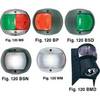
European Style Navigation Lights, Green Side Light, Black Perko
-
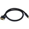
3ft 24AWG CL2 High Speed HDMI to DVI Adapter Cable W / Net Jacket - Black
-
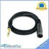
3ft Premier Series XLR Male to 1/4inch TRS Male 16AWG Cable (Gold Plated)
-
PL-258-CP-G Shakespeare Gold Splice Connector for RG-8X or RG-58/AU Co
-
Trident Marine Hose 6" x 6" Fiberglass Splicer