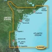
BlueChart g2 Vision - Charleston to Jacksonville - Maps
Model: Brand: Garmin
BlueChart g2 Vision offers the same rich detailed charting of BlueChart g2 to help you get the most out of your unit. In addition, g2 Vision features a growing database of high-resolution satellite imagery, above and below the water 3D perspective, auto guidance technology, aerial photographs for real world reference and coastal roads with points of interest. This product features Cape Romain through St. Augustine including Charleston, Savannah and Jacksonville with the St. John's River covered to the Clay County line. « less
Product Specification
-
General
Product Type: MapsDistribution Media: SD Memory CardFirst Seen On Google Shopping: May 2007 -
Compatibility Information
Designed For: Garmin GPSMAP 4008, 4012, 420, 4208, 420s, 4212, 430, 430s, 430sx, 430x, 440, 440s, 440sx, 440x, 450, 5008, 5012, 520, 5208, 520s, 5212, 525, 525s, 530, 530s, 535, 535s, 540, 540s, 545, 545s, 550, 550s, 555, 555s -
Universal Product Identifiers
Part Numbers: 010-C0709-00, Charleston to JacksonvilleGTIN: 00753759068899
Related Products
-
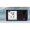
NAVPILOT 700 Autopilot for Inboard without Pumpset
-
32624 SmartPilot X-5 Tiller Grand Prix
-
8264; Map-Clearlake/Lake Berryessa
-
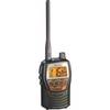
t50421 Marine VHF Hand-Held Radio
-
2680 Nauticast Class B AIS System W/ANTENNAS & Cables
-
1067 Replacement Nicad Battery for 2726 and 2727
-
Cat6a Ethernet Cable | 2ft | Orange | Network | 10 Gigabit
-
14ft 24AWG Cat6 550mhz UTP Ethernet Bare Copper Network Cable - Purple
-
560 VGA + 3.5mm Stereo Audio Male to Male Cable 50 ft. CL2
-
Marine Power 441220 Adapter Plate 262 Holley
-
B45-DT-7 600W Thru-Hull Transducer JRC, Simrad 7-Pin Connector
-
Marine network cable