CFHMPTN6 HotMaps Platinum Multi-Dimensional 3D Lake Maps
Model: CFHMPTN6 Brand: Navionics
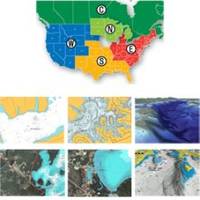
HotMaps Platinum offers 300 of Navionics exclusive high-definition lake maps featuring 1 contours, 3D bottom view, top-down photo/map overlay, and panoramic lake pictures. HotMaps Platinum series also offers 14,000 additional lakes with underwater structure, improved accuracy, major roads, county lines and more. HotMaps Platinum is compatible with most new Humminbird, Lowrance, Northstar, and Raymarine chartplotters. Please call for chartplotter compatibility. « less
Product Specification
-
Universal Product Identifiers
Part Numbers: 11094208, 37630, CF-HMPT-N6, DEF-257887-CFNO6GTIN: 00821245115706
Related Products
-
AP5001 Autopilot with AP50, J50 (12 Amps), Rudder Feedback RF300
-
e7D 7" Multifunction Display with Sonar, Internal GPS, USA Silver Charts, RD418D Radar & No Transducer T70103 c44594
-
Paper Charts ChartKit Book w/ Companion CD - Pacific Northwest 32507
-
Questus Marine, Inc 101" Stainless Steel Support Tube for 400G Questus Marine Radar Mount (Backstay Installation)
-
BlueChart g2 - The Netherlands (HEU018R) - Maps
-
4263541 Repl. Cigarette/Chart Lighter
-
MA7500 Compact Box Marine Speaker, 100 Watts (Pair) c13809
-
Genuine Cobra Ite-t50421-dbd1 Marine VHF Handheld Radio 10
-
100ft Premium Optical Toslink Cable w/ Metal Fancy Connector
-
HBL105GF 15A Female to 30A Male W GFCI Protection
-
/ Quicksilver 30185Q 3 Fuel Connector
-
LED Red 11/64" 120VAC