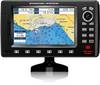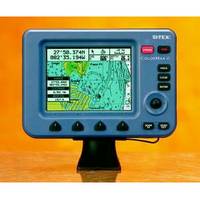
ColorMax 6 6" 16 Ch. GPS/WAAS Charting System
Model: Brand: Scotty
Stores up to 500 waypoints/marks, 25 routes,1000 track points
- Quick-release snap mount, surface mount, protective cover included.
colormax66
Description
The new SI-TEX ColorMax 6 LCD C-MAP MAX/NT+ Charting System offers all the latest features at an affordable price. Features GPS WAAS receiver, new high-speed processor, programmable Guardian!22 Grounding Alarm and with optional Fishfinder module you can add-full featured fishfinder capabilities!
The ColorMax 6 has a 6" color active matrix LCD display with 320 x 240 pixel resolution plus adjustable brightness and contrast with backlighting.
Newly designed high-speed processor with INTEL XSCALE Architecture gives you instant screen changes.
External GPS/WAAS receiver will put your boat within 3 meters of your waypoint in most situations. Available with external GPS/Loran receiver for True Loran Positioning as model ColorMax 6L.
Compatible with the new C-MAP MAX charts, technically the most innovative C-MAP charts ever designed.
Dual C-MAP C-Card slots.
Guardian!22 Programmable Anti-Grounding feature lets you know if your current course takes you within preset distance of charted shoals, obstructions or other areas where the water is too shallow for your vessel's draft.
Optional ES502 Fishfinder Module adds full-featured fishfinder capabilities.
Depth Graph feature accepts input from onboard sounder or optional Active Transducer to display graphic presentation of vessel's current depth and recent depth history.
Split-screen displays.
North-up or Track-up modes.
Stores up to 500 waypoints or marks, 25 routes and 1000 track points.
Built-in worldwide background chart.
Port Info feature uses local C-Card information to calculate tide graph for local ports.
Find Function uses local C-Card to locate nearest boatyard, bank, even the closest shower.
Joy stick pointing device controls on-screen cursor to plot, scroll, pan, and zoom from vast sea areas to harbor charts.
Softkeys and comprehensive on-screen menu for easy access to all system features.
GOTO and MOB functions.
Thirteen selectable languages.
Coordinates displayed in Lat/Lon, Loran TD's, UTM or OSGB.
Data can be downloaded onto optional C-MAP MAX/NT+ C-Card memory cartridges.
NMEA-0183 dataport for interfacing data with other on-board electronics.
Displays wind data when connected to wind instrument through NMEA-0183 interface.
Weatherproof construction.
Quick-release snap mount, surface mount kit and protective cover included.