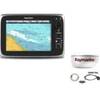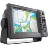
CP590 12 GPS Chartplotter w/Coastal Charts Map
Model: CP590 Brand: Standard Horizon
CP590 - WAAS GPS Chart Plotter External Antenna with built-in C-Map Cartography Find every destination in style with the CP590 WAAS enabled GPS Chart Plotter. Preloaded with detailed maps for coastal navigation of USA including Alaska, Hawaii and Great Lakes, Canada, Bahamas, Caribbean, Cuba, Mexico, Puerto Rico, and Central America. Providing up to 10-foot accuracy the CP590 is designed to navigate you quickly and accurately to your destination. The CP590 boasts a crisp high-definition 12-inch 800x600 (SVGA) sunlight viewable TFT display. The 5 user programmable hot keys allow quick and easy access to a number of preprogrammed navigation displays. Connect your CP590 to two video sources and watch your favorite DVD, play your favorite video game, or monitor your engine room in full screen or Picture in Picture. In addition, the CP590 has one VGA Video output that connects to an external TV or Monitor allowing your passengers to view the vessels progress to a favori « less
Product Specification
-
Universal Product Identifiers
Part Numbers: 40777, CP500, CP590, DEF-258647GTIN: 00788026126040
Related Products
-
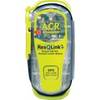
2881 ResQLink + 406MHz GPS PLB Buoyant
-
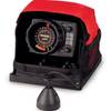
LX-5 Dual Beam True Color Sonar Flasher System
-
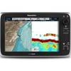
E70014 C127 Multifunction Display w/Sonar - No Preloaded Cha
-
Package(c95 with aus, NZ, S. America, Asia Chart, 4KW 24 Inch Digital Radome & Radar Cable)
-
BlueChart g2 Vision - Mobile to Lake Charles - Maps
-
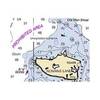
Puget Sound (Small Craft) Chart
-
AP2404 Autopilot System 32210
-
0528007PLB 1.25 Unmarked Deck Fill Bronze
-
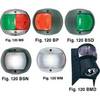
European Style Navigation Lights, Green Side Light, Black Perko
-
GP1920C-NT VX2 Chartplotter C-Map NT
-
10.0 Sbeg Generator
-
700 Series 797c2 SI Combo NVB - Marine Chartplotter - 5" color - 640 x 480