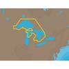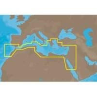
EM-M112 C-Card Format Aegean Sea
Model: EM-M112 Brand: C-Map
South Mediterranean Sea and Aegean Sea: Greece to entrance of Sea of Marmara (partial coverage). SW Turkey, Syria, Lebanon, Israel, Egypt (including Suez Canal and Gulf of Aqaba) Libya and Saudi Arabia. Red Sea coverage ends south of Jeddah, Saudi Arabia. Coverage of the Mediterranean coast of Africa including Egypt, Libya, Tunisia, Algeria to Agadir, Morocco. Also covers the SW coast of Sicily, The southern tip of Sardinia and parts of Southern Spain from Adra to Sines, Portugal. « less
Product Specification
-
Universal Product Identifiers
Part Number: EM-M112C-CARD
Related Products
-
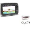
Package(e7D with Sonar & USA Coastal Chart, 4KW 18 Inch Digital Radome & Radar Cable)
-
NA-C101 C-Card Format - Superior, Huron, No Chan Grgn
-
Elements of Navigation, Chart, Lead, & Log Deviation & Compass Compensation, Piloting, Dead Reckoning, Nautical Tables [Book]
-
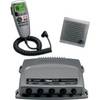
010-00756-00 VHF 300 Marine Radio
-
AP2404 Autopilot System 32210
-
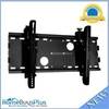
Adjustable Tilting Wall Mount Bracket for LCD LED Plasma (Max 165Lbs, 23~37inch) - Black (No Logo)
-
30ft 24AWG Cat5e 350MHz UTP Bare Copper Ethernet Network Cable - White
-
10ft 14AWG Power Cord Cable w/ 3 Conductor PC Power Connector Socket (C13/5-15P) - Black
-
Cat6a Ethernet Cable | 3ft | White | Network | 10 Gigabit
-
FA-CM-90 - Field CONNECTOR, Male Micro/Mid, 90?
-
19811 PL259 with Adapter
-
FUGMAR-4 Marine 4 PC Navigation Software v4.5 - Upgradable to 5