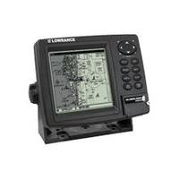
GlobalMap 4800M - Marine GPS receiver - 5" monochrome - 480 x 480
Model: 4800M Brand: Lowrance
GlobalMap 4800M is a Precision Lowrance GPS+WAAS mapping system with superb high-resolution detail for marine and automotive use. So easy-to-use. So intelligent. And so smartly affordable!
Product Specification
-
General
Product Type: GPS receiverRecommended Use: MarinePreloaded Maps: USA, HawaiiReceiver: 12 channelCard Reader: SD Memory CardInterface: NMEA 0183, NMEA 2000Compatible Software: Lowrance Fishing Hot Spots Elite, Lowrance FreedomMaps USA Topo, Lowrance LakeMaster Pro Maps, Lowrance MapCreate USA Topo, Navionics chartsSBAS: WAASAntenna: ExternalUpdate Rate: 1/secondFirst Seen On Google Shopping: August 2007 -
Display
Type: TFT - monochromeDiagonal Size: 5"Resolution: 480 x 480Display Illumination: Yes -
Navigation
Waypoints: 1000Routes: 100Waypoints per route: 10000 -
Miscellaneous
Protection: WaterproofIncluded Accessories: Protective cover -
Dimensions & Weight
Width: 6.9 inDepth: 3.4 inHeight: 5.4 in -
Manufacturer Warranty
Service & Support: 1 year warranty -
Universal Product Identifiers
Part Numbers: 117-04, 117-041, 4800MGTIN: 00042194523262
Related Products
-
1500 Autopilot with Type 1 (60Ci/Min) with Rotary Feedback 10090009
-
G10 10" Mfd W/2KW Sonar 408020-1
-
Max AU-M005 W60 Australia-MAX
-
Electronic Charts Uflex Hydraulic Hose Kit 14' Two Hoses
-
Cabin Door Hook, Bronze, 1-1/2"
-
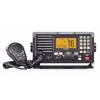
IC-M604 VHF Marine Transceiver
-
Children's Life Jacket PFD 2
-
SP36-12 Autopilot Virtual Feedback 30CI Pumpset
-
Innovative Lighting LED Deck Mount Navigation Light - White
-
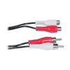
Video / audio extension cable - Female RCA phono x 2 to M RCA phono x 2
-
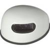
GA 30 - GPS antenna - Marine
-
e7D 7 Multifunction W Sonar, Internal GPS - USA Silver Cha