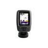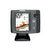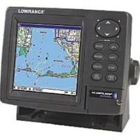
GlobalMap 5200C - Marine GPS receiver - 5" color - 480 x 480
Model: 5200C Brand: Lowrance
A superb new color GPS chartplotter with an external precision GPS+WAAS satellite antenna to allow for custom placement and installation. A 5" screen displays at 480 x 480 resolution with the unique SolarMax enhancement to produce maximum visibility in all lighting scenarios.
Product Specification
-
General
Product Type: GPS receiverRecommended Use: MarineReceiver: 12 channelCard Reader: SD Memory CardInterface: Serial, NMEA 0183, NMEA 2000Compatible Software: Lowrance Fishing Hot Spots Elite, Lowrance FreedomMaps USA Topo, Lowrance LakeMaster Pro Maps, Lowrance MapCreate USA Topo, Navionics chartsSBAS: WAASAntenna: ExternalFeatures: Backlit keypadFirst Seen On Google Shopping: August 2007 -
Display
Type: TFT - colorDiagonal Size: 5"Resolution: 480 x 480Display Illumination: Yes -
Navigation
Waypoints: 1000Tracks: 100Tracklog Points: 10000Routes: 100 -
Connections
Interfaces: Serial -
Miscellaneous
Protection: Waterproof -
Dimensions & Weight
Width: 6.9 inDepth: 3.4 inHeight: 5.4 in -
Manufacturer Warranty
Service & Support: 1 year warranty -
Universal Product Identifiers
Part Numbers: 000-0123-37, 123-37, 5200CGTIN: 00042194529493, 00042194529516, 00042194529561
Related Products
-
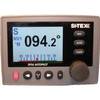
E32122 SR6 Sirius Satellite Weather Receiver with Network Sw
-
Package(e95 with aus, NZ, S. America, Asia Chart, 4KW 18 Inch Digital Radome & Radar Cable)
-
T52087 4KW 72quot; Open Array Super HD W/15M Cable
-
NT+ - St. Lawrence River and Approaches NA-C202
-
Fishfinder echo 300c - Fishfinder - included transducer - dual-beam
-
SP36-11 SP-36 Autopilot System
-
6149 32ft 10M USB 2.0 A Male to A Female Active Extension / Repeater Cable (Kinect & PS3 Move Compatible Extension)
-
HDMI to Micro HDMI Cable, High Speed with Ethernet, 10 ft
-
USB extension cable - 9 pin USB Type A - M - 9 pin USB Type A - F - 10 ft - PC
-
HBL26CM13 30A Female Connector
-
010-10742-00 Control Area Network (Can) Kit
-
700 Series 747c - Fishfinder - included transducer : XNT-9-20-T - dual-beam