Max Wide International cwidei
Model: Brand: C-Map
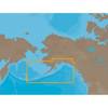
C-map Max Compatible Plotters List Please Select a Chart Number from the Picture Below and Type in the Chart Number in the Box Next to Shopping Cart Features Dynamic NavAids include detailed information on navigational aids, including name, color, information on frequency, range of the light, etc. Dynamic tides and currents predict the time, level, direction and strength of currents and tides. Guardian Alarm performs an automatic forward-scanning check for obstacles. Use this feature as an added backup to alert you if you head toward a potentially harmful object. Photos and diagrams in high-definition of ports, marinas and significant navigational marks will help you to familiarize yourself with new destinations and passages. Route-check is an extension of Guardian Alarm, helping keep you safe by indicating obstacles along the segments between waypoints. Depths and land elevation show the usual depth information and the colors make it easy to distinguish different water depths and land elevations. Detailed harbor charts so docking in unfamiliar ports is no problem. You have precise layouts of thousands of marinas, including slip spaces, restricted areas and other valuable navigation information. Perspective view gives a bird's-eye view of your navigation area, it tilts the chart view to a 45-degree angle. C-Marina Port Database has details on more marinas than other charts on the market. Multi-language capability All C-MAP by Jeppesen charts can be displayed in both English and the local language of each region. More than 140 languages are available Australia & New Zealand & Oceania Number Code Coverage W60 M-AU-M005 AUSTRALIA W61 M-AU-M207 PAPUA NEW GUINEA W63 M-AU-M222 NEW ZEALAND, CHATHAM I. « less
Product Specification
-
Universal Product Identifiers
Part Number: cwidei
Related Products
-
Inked Photography Series Kick Drumhead 24 Inch Boat Props
-
LX-7 Color LCD Sonar
-
NA-C802 C-Card Format Gulf of Alaska
-
SP110RF-4 SP-110 System w/Rudder Feedback & Type T Mechanical D
-
Max Lakes North NA-M017 c30544
-
GPSMAP - 531/531S - v.2.3 - GPS software (update)
-
E15026 Life Tag Wireless Man Overboard System (Extra Tags)
-
ZDIGWLEXT USB Self Powered Extension Cable WL400/500
-
M72 220V Charger Euro with BC-147E
-
Split Connector 6ft Right Angle RJ45 Plug
-
HBL64CM55 Y Adapter 2 50A 125V Cords - 50A 250V
-
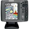
700 Series 787c2 Combo - Marine Chartplotter - 5" color - 640 x 480