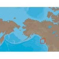
NA-C705 Furuno FP Format Banks Is BC Sumner Strait AK
Model: NA-C705 Brand: C-Map
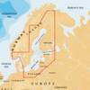
With are Electronic Sharts C-Maps we have: Olympia, Washington to Port Mcneill, British Columbia. Nannose to Victoria to Cape Scott Texada Island to Caamano Sound Cape Caution to Portland Canal Banks Island, British Columbia to Sumner Strait, Alaska Dixon Entrance to Icy Bay Gulf of Alaska Western Alaska NA-C705 Banks Island, BC To Sumner Strait, Alaska NT+ Cartography NT+ electronic charts feature much wider coverage areas at substantially lower prices. « less
Product Specification
-
Universal Product Identifiers
Part Numbers: 20183, NA-C705FURUNOFP
Related Products
-
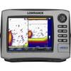
HDS-8 Insight USA Mltfnc 83/200 Fishfinder/Chartplotter 34252
-
GRH4D HD Ethernet Radar Dome 21" 40381
-
44XG/SD Baltic Sea Finland, Sweden, Norway South
-
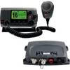
VHF 100 & AIS 300 Marine Communication Bundle K10-00169-00
-
E25024 Console Mounting Bracket - ST40 INSTRUMENTS
-
T70080 P70, X-10 Type 1 Linear Autopilot Package f/Sailboats
-
35ft Premier Series XLR Male to 1/4inch TRS Male 16AWG Cable (Gold Plated)
-
TNCM-58-G TNC Type Male Connector for RG-58X Coax
-
SB-6BK Switch Box 2 Units 1 Transducer Black Connector
-
InterLink - Fishfinder InterLink system connection module
-
809-0915 AGS Automatic Generator Starting Device
-
M92d Hand Held VHF