NA-M024 SD Card Format US West Coast and Haw
Model: NA-M024 Brand: C-Map
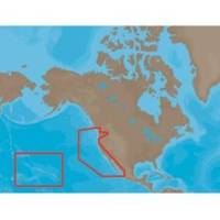
NA-M024 => USA West Coast and HawaiiCoverage of the Pacific Coast of the United States, including all of the coasts of California, Oregon and Washington. Coverage of Baja California and Mexico down to Puerto Vallarta. Detail of the Columbia River, Sacramento River, Willamette River. Snake River and San Joaquin Rivers are also included. Full coverage of Puget Sound and the San Juan Islands up to Point Roberts is also included. Additional coverage of the Hawaiian Islands out to Midway and Johnston Atoll is also included. « less
Product Specification
-
Universal Product Identifiers
Part Numbers: 30147, CMANAM024SD, M-NA-M024, NA-M024-SD, NA-M024SDCARDGTIN: 000000165847, 00686074002746
Related Products
-
Video Sboatu3dvd DVD Boaters Guide to Mayday
-
M81136 T2 Rotary Drive 12V
-
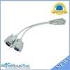
MP Rs232 Serial Mouse or Monitor Splitter Cable - 1DB9 Female to 2 DB9 Male 4640
-
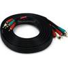
12ft 22AWG 5-rca Component Video/audio Coaxial Cable (RG-59/U) - Black
-
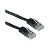
Network cable - CAT 6 - RJ-45 - M - Unshielded twisted pair (UTP) 35 ft - Black
-
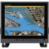
MU150HD 15 Inch Color LCD Marine Monitor
-
1614g 38 100 Pcs Ring Heat Shrink Connector Blue
-
18-8801-1 Premium Marine Spark Plug Wire Leads
-
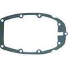
Marine Products Gasket, Adapter Plate 9-60042
-
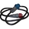
NAC-FRD2FBL NMEA Network Adapter Cable 127-05
-
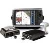
GPSMAP 4212 Network Bundle Includes GSD22 & Gxm51 p2683
-
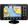
7" GPS Chartplotter W/MAPS