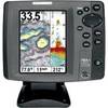
Radar 5208 Package with GMR18 4KW Radome
Model: GMR18 Brand: Garmin
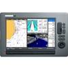
The package includes Garmin GPS Chartplotter Garmin GPS Antenna Garmin Radome Garmin Power, GPS, and Radar cables Manuals This flagship marine navigator is missing just one thing buttons. The GPSMAP 5208 features an unprecedented touchscreen interface, along with preloaded BlueChart g2 maps of the U.S. coast and an 8.4" screen that makes navigation as easy as pointing your finger. By connecting to the Garmin Marine Network, you can add sonar, radar and weather. For even more advanced features, you can add the optional BlueChart g2 Vision card. View Detailed Graphics and Video The GPSMAP 5208 features highly-detailed BlueChart g2 marine cartography of the costal United States, including Alaska, Hawaii and the Bahamas. For other areas, the 5208 has a worldwide basemap with high-quality satellite images in place of more traditional maps. With the SD card slot, you can add additional maps without having to connect to a computer. The 5208? s large screen displays crisp, high-resolution graphics so you can easily see where youre going. To keep tabs on your engine room or other area of your boat, you can also connect a live video feed with the 5208's video input/output options. Add Extras with BlueChart g2 Vision With the optional BlueChart g2 Vision SD card, you can add a whole new dimension of exceptional features to your chartplotter. 3D mariner's eye view or fish eye view provides you with a 3-dimensionsl perspective of map information, both above the waterline and below it. High-resolution satellite images and aerial photographs help you orient yourself in unfamiliar areas. Auto Guidance technology searches through all relevant charts to create a route you can actually follow one that avoids obstacles, shallow water, buoys and other obstructions. Connect to the Garmin Marine Network The 5208 connects easily to the high-speed Garmin Marine Network, so you can interface with additional MFDs and add remote sensors. Once connected, you can share information between the 5208 and other chartplotters on your boat. You can also add high-powered radar, sonar, and XM satellite weather and radio to your system. D, Jan, 2008 | Download NMEA 2000 Network Fundamentals, Rev. A, Jan, 2008 | Download Owner's Manual, Rev. B, Jul, 2007 | Download Quick Reference Guide, Rev. B, Jan, 2008 | Download EL Quick Reference Guide (Greek), Rev. B, Jan, 2008 | Download RU Quick Reference Guide (Russian), Rev. B, Jan, 2008 | Download Some downloads may require Adobe Acrobat Reader. Download a free copy here . « less
Product Specification
-
Universal Product Identifiers
Part Number: gmrpack35
Related Products
-
AP5007 Autopilot with AP50, J50, Rudder Feedback RF300, HPU200-24V
-
V-410 Automatic Ice Fishing Sonar Digital Charger
-
MDS-1 2KW 12 Inch Dome Radar Add-on with 10 Meter Cable wmsd1
-
432-0004-03-00S First Mate Handheld Thermal Imager
-
100ft 24AWG Cat6 550mhz UTP Ethernet Bare Copper Network Cable - Purple
-
30ft 24AWG Cat6 550mhz UTP Ethernet Bare Copper Network Cable - Blue
-
Navigation Light Stern
-
700 Series 787c2i Combo - Marine Chartplotter - 5" color - 640 x 480
-
010-11418-00 - 10M Marine Heading Sensor Cable NMEA0183
-
5-Way Male and Female Trailer Wire Connector 24-inches
-
Trident Marine Hose 6" x 6" Fiberglass Splicer
-
E62115-US - C140Wide 14 MFD, US Charts, Int GPS