ROSE POINT ECS
Model: ECS Brand: Sailor
Commercial Grade Electronic Charting and Navigation Software for Microsoft Windows ®
Rose Point ECS improves operational efficiency, situational awareness, and decision making with straightforward, uncluttered displays and controls that provide instant access to the information you need to navigate safely.
Overview What's New Specifications Training Videos Support
Navigation
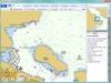
When underway, Rose Point ECS provides you with the information you need with a quick glance at its clear, customizable displays and logical controls.
Passing Point Predictors indicate where you will meet other vessels in confined waterways, even around bends in a river
The Rate of Turn Course Predictor helps reduce over steering by indicating where the vessel will be in the future based on the current speed and rate of turn
Advanced AIS support includes closest point of approach calculations and alarms and AIS vessel track saving
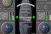
Fully customizable instrument panels and screen layouts
The Voyage Recorder records all navigation data as well as radar, sounder, and video images for playback at a later time
Chart Compatibility
Rose Point ECS can use the official NOAA ENC® and NOAA RNC® charts directly; there is no need to purchase US charts in a proprietary format. Rose Point ECS even makes it easy to download and install these free charts. Official worldwide charts are available for purchase from Rose Point and other suppliers.
Semi-Automatic Chart Updates
NOAA ENC® and NOAA RNC®
USACE IENC (2.0 and 2.1)
S-57 ENC (including S-63 encrypted)
Maptech BSB (raster nautical charts)
Admiralty Vector Chart Service (AVCS)
Additional Information
Rose Point ECS provides tightly integrated, easy to use, and completely searchable supplementary navigation information including:
Unlimited Routes and Waypoints
Boundary Areas with Optional Speed Limits
Document file based route and mark organization tools
Easy file transfer and printing facilities
US Port and Waterway Facilities Guide
US Coast Pilot®
International Sailing Directions
Tide and Current predictions
Weather forecasts and observations
Gulf of Mexico Lease Block Boundaries
Worldwide Gazetteer
USACE Hydrographic Surveys
NAVTEX message display (required NAVTEX receiver)
Sensor Compatibility
NMEA 0183 / IEC 61162 and NMEA 2000®
GPS, depth, speed, wind, AIS, heading, etc.
Configurable port priorities and filtering
Sensor offsets for accurate vessel positioning
Video Cameras
Radar overlay option available
+Inland Add-On
The features of +Inland are ideal for vessels operating on the inland waterways.
Mile Markers instead of latitude/longitude
Graphical Tow Configuration editor
Boat and tow are shown to scale on charts
River Stage observations and forecasts