Chartplotters
-
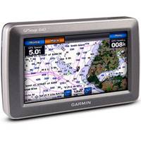
GPSMAP� 640 Marine & Automotive GPS, North America
-
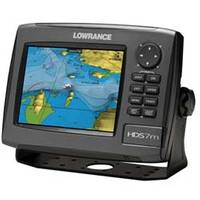
HDS-7m Gen2 Multifunction Chartplotter
-
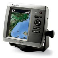
GPSMAP� 526s Chartplotter with Dual-frequency Transducer
-
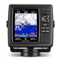
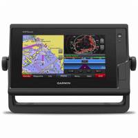
GPSMAP® 547xs
An Amazing Chartplotter/Sounder Combo5" VGA display10Hz GPS/GLONASS receiverHD-IDâ 1E¢ sonarWireless connectivityU.S. coastal and inland mappingGPSMAP 547xs combination chartplotter/sounder allows for easy visibility, day or night. Whether it is flat, flush or swivel-mounted, it will be the focal point of your helm. It includes our hallmark user-friendly interface as well as U.S. coastal and inland mapping.Super-fast 10 Hz GPS/GLONASSWith the integration of a 10Hz GPS/GLONASS receiver, the 547xs refreshes position and heading up to 10 times per second. It displays constant and fluid on-screen location and proves to be incredibly accurate when marking waypoints and navigating.Advanced Echo HD-ID SonarIn addition to the integrated receiver, GPSMAP 547xs also allows for sonar recording. This feature coordinates the timing of the sonar return in relation to the boatâ AC!22s position â AC 1D so every one of the available 5,000 waypoints will be accurate and precise. It's an absolute must when locating and pinpointing the next hot fishing spot.Spread-Spectrum CHIRP SonarWhen used with a compatible CHIRP transducer (sold separately), GPSMAP 547xs displays crystal-clear sonar images to help find the next hidden fishing spot, ship wreckage or diving location. With our Spread-Spectrum technology, you can see target separation and resolution at extraordinary depths, and dial into specific frequencies to target certain species of sport fish. Bottom contours are more visible, and signal noise can be suppressed at greater depths to provide a more timely interpretation of whatâ AC!22s below for safer navigation and better fishing.
-
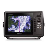
GPSMAP 742 Chartplotter
Full chartplotting capability, wireless connectivity and much more in this 7 1D diagonal chartplotter.Experience an advanced navigation solution with the compact GPSMAP® 742 chartplotter, with a sunlight-readable multi-touch touchscreen display. With built-in wireless connectivity for Garmin mobile apps and VIRB® action camera integration, you can stay connected to the newest media. Its 10Hz GPS/GLONASS receiver delivers smooth on-screen navigation. This compact plotter offers full-network compatibility for the Garmin Marine Network, which allows support for sharing sonar, maps, user data, radar, IP cameras and Panoptix all-seeing sonar among multiple units. Plus, there 19s NMEA 2000 and NMEA 0183 support for autopilots, digital switching, weather, VHF, AIS and other sensors.Preloaded premium mapping features both coastal and inland mapping, including both BlueChart® g2 HD charts for the US, Canada and Bahamas and LakeVü HD maps.Key Features
-
GPSMAP 820
8" Keyed Chartplotter for Cruising, Sailing or Fishing 8 1D color SVGA display with keyed control Preloaded with worldwide basemap High-sensitivity internal 10 Hz GPS/GLONASS receiver Compatible with LakeVü!22 HD Ultra, BlueChart® g2 and BlueChart g2 Vision® Supports all Garmin marine radarThe 8 1D color GPSMAP 820 keyed chartplotter has a preloaded worldwide basemap. The built-in 10 Hz GPS/GLONASS receiver updates your position and heading 10 times per second.NMEA 2000® SupportThis combo allows you to add more capabilities to your boat. It provides NMEA 2000 support so you can see valuable information on your screen for Garmin autopilot, engine data, SiriusXM Weather radar and more.NetworkingThe GPSMAP 820 offers select networking capabilities that allow you to share features with other compatible GPSMAP units, such as radar, GCV 10 DownVü and SideVü scanning sonar, supplemental maps, and user data, including waypoints, routes and tracks. User data entered into one chartplotter can be automatically synced with other chartplotters in a network.Special Sailing FeaturesSupported sailing features include laylines, enhanced wind rose, heading and course-over-ground lines, true wind data fields and tide/current/time slider.GND!22 10 Black Box InterfaceThe GND 10 black box interface seamlessly integrates Nexus instruments and sensors with the Garmin family. It converts data between the Nexus network and NMEA 2000 to provide trouble-free compatibility between Nexus and Garmin products, including gWind!22 and gWind Race wind transducers.Compatible with gWind TransducersGarmin gWind, gWind Wireless and gWind Race transducers feature twin-fin technology with 3-bladed propeller. Connect to the NMEA 2000 and compatible Garmin chartplotters via the GND 10 black box bridge.View and Control Your Device From an iPhone® or iPad®Garmin Helm allows you to view and control your compatible Garmin chartplotter from an iPhone or iPad 14 while providing enhanced situational awareness for the mariner. Easily switch between portrait and landscape mode to accommodate mounting preferences. Using your Apple digital mobile device, you can even record a movie of your chartplotter screen to share with friends and family. Download from the App Store!22 today.New Charts Guarantee BlueChart G2 BlueChart G2 Vision LakeVü HD Ultra
-
GPSMAP 8000
The Power of Simple!22The GPSMAP 8000 Glass Helm series provides the most powerful, technologically advanced, easiest to use, chartplotter solutions we have ever offered. It is a sleek, completely integrated glass helm made powerfully simple. FEATURESChoose between multifunction display (MFD) or Black Box systemThe GPSMAP 8000 MFD series includes your choice of 8 1D, 12 1D and 15 1D touchscreen displays. GPSMAP 8500 Black Box Systems can be equipped with your choice of Garmin Marine 15 1D, 17 1D and 19 1D touchscreen monitors, as well as an option that includes worldwide BlueChart® g2 cartography.Multi-touch displaysTouchscreen displays feature pinch-to-zoom and other convenient controls that put everything at your fingertips, including various sonar technologies including CHIRP, integrated autopilot, connectivity, apps, engine data, multimedia and more.Full System IntegrationIntegrates various sonar technologies, integrated autopilot, connectivity, apps, engine data and multi-media. User data is automatically synced for all networked 8000 series chartplotters across multiple helms. A full digital switching system utilizes CZone technology making nearly all controls available at your fingertips either at the helm, programmed into the remote key fob, or from an app on your tablet provided by CZone by MasterVolt.SmartMode!22Everything is integrated, right at your fingertips, right on the screen. Unique SmartMode control allows you to switch all monitors in sync from one to another without manually switching each monitor separately. Garmin Helm!22 a free app, allows you to view and control your compatible Garmin chartplotter from an iPhone® or iPad®. Use SmartMode to easily switch between multiple chartplotters with screen thumbnails by station. (Requires Garmin Marine Wi-Fi Adapter.)10 Hz GPS (GPS/GLONASS)External 10 Hz GPS/GLONASS updates your boat 19s position and heading 10 times per second displaying fluid vessel movement that puts you right above where you want to be.Garmin Card ReaderProvides convenient remote mounting and a single access point for two SD® card slots for mapping. You can add multiple card readers for additional access points. Waterproof magnetic door allows card reader to be mounted horizontally or vertically.Garmin Remote Input Device (GRID)A remote device that provides full control of all GPSMAP 8000/8500 series units. Rotary knob and joystick controls provide navigation through menus and screens. Allows you to seamlessly navigate between monitors at a station. Control single or multiple monitors with one device. Supports multiple devices per station. GRID can rotate to allow vertical or horizontal installation. Can be integrated into a captain 19s chair.Special Features for SailingSupported sailing features include laylines, enhanced wind rose, heading and course-over-ground lines, true wind data fields, and tide/current/time slider.FLIR Camera CompatibleControl fix-mounted FLIR M-Series and MD-Series thermal night vision systems from your Glass Helm.Compatible with Garmin Meteor Audio SystemThe Garmin Meteor!22 300 black box brings music to your boat controlled through your chartplotter. Easy plug-and-play NMEA 2000® connections. Quick access to AM/FM radio tuner media and volume. Support for Apple® digital mobile devices (including Lightning), USB, and devices for Android.FUSION-Link Entertainment System CompatibleEnjoy the ability to control all compatible FUSION Link enabled audio systems directly from your compatible chartplotter display.A beautiful additionGive your boat a sleek, beautiful glass helm look with the ultimate Garmin integrated navigation system. MFDs and Garmin Marine Monitors can be installed with either a low-profile flush mount or custom flat mount to give your boat a smooth glass helm.Integrated AutopilotEasily access your autopilot control from any display.Powerfully simple user interfaceCombined with a user-interface that 19s designed for efficiency, the 8000-series is perfect for any helm. The refreshed interface has been streamlined to help access the most important menus and settings and provides a more intuitive experience. With a user control bar docked at the bottom of the screen, information such as waypoints, autopilot and the home menu are always only a touch away.
-
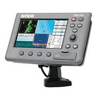
NEW! SNS-700 7 1D HD WVGA Color LCD
DescriptionHigh Definition Daylight Viewable DisplayPlenty of room for split-screen displays of chart, sounder and radar. Uses C-MAP MAX on SD Choice of internal or external GPS antenna Flush mount or quick disconnect IP67 waterproof rating Available with built-in 600W dual-frequency sounder Integrates with MDS Radar Sensor, Metadata AIS Modules.Also available as EC-7
-
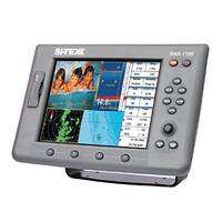
SNS-1100 10.4 1D HD SVGA Color LCD
DescriptionSerious multi-function performance for larger vessels. Uses C-MAP MAX on SD Includes external GPS/WAAS Antenna IP67 waterproof rating 2 Video Inputs/1 Video Output Connects with 600W dual-frequency Black Box sounder Integrates with MDS Radar Sensor, Metadata AIS ModulesAlso available as EC-11
-
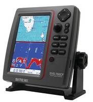
SVS-760C Digital Chartplotter
DescriptionThe SVS-760CF is an extremely powerful chartplotter, offering the ability to run both types of cartography in the same machine, enabling boaters to select the platform that works best for their region, personal preference and specific boating needs on any given voyage. This machine also provides Navionics Sonar Chart Bathymetric recording capability, allowing boaters to survey their own areas and have this data added to the Navionics Sonar Chart Database. The unit is also Navionics Community Layer capable, allowing users to download the latest information for their chart area.The SVS-760C offers tremendous memory, with storage for 20,000 marks/waypoints, 100 routes and 50,000 track points. It is also designed for easy integration with SI-TEX 19s Metadata AIS module (or other AIS receivers) for enhanced situational awareness and safety at sea.All this technology is contained in a rugged, compact IPX-7 waterproof case that can be mounted indoors or out, on any style or size of boat.
-
GPSMAP 742 Chartplotter
SHOP BY CATEGORYNEW PRODUCTSADVICE & HOW-TOSALEOUTLETMarine Electronics >GPS & Radar >Multifunction Displays & Combos GPSMAP 742 Chartplotter with U.S. BlueChart g2 and LakeVu HD Inland ChartsEnlarged view of picture, opens dialogProduct images carousel, showing slide 1 of 1VideoGARMINGPSMAP 742 Chartplotter with U.S. BlueChart g2 and LakeVu HD Inland Charts (0) 0 stars, 0 reviews, skips to reviews|Write The First Review1Answered QuestionAsk A Question$899.99In stock online.Only 3 in stock!1Add To Cart, Opens DialogFind in Store, opens dialog Add to My ListPLUS Product Protection PlanAdd extra coverage from the date of purchase beyond the manufacturer 19s warranty. View Details2 Year 13 $109.491 Year 13 $79.44Model # 17984600 | Mfg # 010-01738-01 | UPC # 753759168216PRODUCT OVERVIEW SPECS ADVICE REVIEWS PRODUCT Q & AFull chartplotting capability, wireless connectivity and much more in this 7 1D diagonal chartplotter.Experience an advanced navigation solution with the compact GPSMAP® 742 chartplotter, with a sunlight-readable multi-touch touchscreen display. With built-in wireless connectivity for Garmin mobile apps and VIRB® action camera integration, you can stay connected to the newest media. Its 10Hz GPS/GLONASS receiver delivers smooth on-screen navigation. This compact plotter offers full-network compatibility for the Garmin Marine Network, which allows support for sharing sonar, maps, user data, radar, IP cameras and Panoptix all-seeing sonar among multiple units. Plus, there 19s NMEA 2000 and NMEA 0183 support for autopilots, digital switching, weather, VHF, AIS and other sensors.Preloaded premium mapping features both coastal and inland mapping, including both BlueChart® g2 HD charts for the US, Canada and Bahamas and LakeVü HD maps.
-
SVS-760CF Chartplotter/Sounder Combo
DescriptionThe versitile SVS-760CF is a combination digital echo sounder and chartplotter with built-in 50-channel GPS receiver capable of running both C-MAP MAX and Navionics Gold cartography.The 50/200kHz SVS-760 sounder features powerful 600W output and a vertically oriented, sunlight viewable 7.5 1D color LCD display that optimizes presentation of bottom composition/contour and fish targets beneath the vessel. With depth ranges down to 4,800 feet, a high-resolution color LCD display, clearly marked controls and large, easy-to-use controls, this sounder is ideal for professional users as well as serious sportfishing duty.SI-TEX 19s digital sounding technology eliminates unwanted noise and provides a sharp image of the seabed and fish targets. The unit 19s high-speed CPU delivers seamless zooming and provides superior readings even at higher boat speeds. This powerful processor also ensures that even the smallest fish targets are presented on the display. Among the SVS-760CF 19s long list of professional sounder features are White Line/Black Line Bottom Discriminator to separate bottom-hugging fish from the sea floor, Auto/Manual Gain and Range Selection, Bottom Lock, Bottom Zoom and A-Scope. Users can select from various fish symbols based on the size and type of targets being marked.For enhanced operation and awareness, alarms are provided for Depth, Fish School and Water Temperature. The SVS-760CF also features an SD card slot, allowing fishermen to back up information and record data on important fishing spots.The SVS-760CF delivers all this fishfinding performance with the added capabilities of a powerful chartplotter. The ability to run both types of cartography in the same machine allows boaters to select the platform that works best for their region, personal preference and specific boating needs on any given voyage. This machine also provides Navionics Sonar Chart Bathymetric recording capability, allowing boaters to survey their own areas and have this data added to the Navionics Sonar Chart Database. The unit is also Navionics Community Layer capable, allowing users to download the latest information for their chart area.The SVS-760CF offers tremendous memory, with storage for 20,000 marks/waypoints, 100 routes and 50,000 track points. It is also designed for easy integration with SI-TEX 19s Metadata AIS module (or other AIS receivers) for enhanced situational awareness and safety at sea.All this technology is contained in a rugged, compact IPX-7 waterproof case that can be mounted indoors or out, on any style or size of boat.
-
TRAWL PLOT 12SD 12.1" Color LCD 16 Ch. GPS/WAAS Charting System
Designed for the professional- One-Touch event mark for easy storage & retrieval of gear marks.- Stores up to 5000 waypoints/marks, 50 routes and 50,000 track points- Unlimited storage of track/route data on SD memory cards- Works with optional MDS Radar SensortrawlDescriptionAdvanced C-MAP MAX/NT+ Charting System for the Professional features High-speed Intel Xscale Processor, Easy Operation, Unlimited Storage, GPS WAAS Positioning, Large 12.1" Daylight Viewable Display and expands to an all-in-one GPS Chart/Fishfinder/Radar with optional sensors. 12.1" XVGA Color LCD TFT display with 800 x 600 pixels for high-definition. External GPS/WAAS receiver will put your boat within 3 meters of your waypoint in most situations. Available with external GPS/Loran receiver for True Loran Positioning as model TrawlPlot 12SDL. Newly designed high-speed processor with INTEL XSCALE Architecture gives you instant screen changes. Zoom level changes appear in the blink of an eye, regardless of the amount of screen detail. Compatible with the new C-MAP MAX charts, technically the most innovative C-MAP charts ever designed. System operates as a C-MAP MAX based chart plotter with four C-Card slots, or as a track plotter without map display. Guardian!22 Programmable Anti-Grounding feature* lets you know if your current course takes you within preset distance of charted shoals, obstructions or other areas where the water is too shallow for your vessel's draft. Expands to an all-in-one GPS Charting System/Fishfinder/Radar with optional ES502 Fishfinder Module and optional 2kW to 4kW MDS Radar Sensors. Depth Graph feature accepts input from onboard sounder or optional Active Transducer to display graphic presentation of vessel's current depth and recent depth history. Operates in North-Up or Track-Up modes. Coordinates displayed in Lat/Lon, Loran TD's, or UTM. Displays Loran TD's even when position data is supplied in Lat/Lon coordinates. Alphanumeric designations for easy identification of waypoints and marks. "One-Touch" event mark 14for easy storage and retrieval of gear marks. Unlimited storage of track and route data on optional SD (secure digital) memory cards. Each disk can store up to 80,000 track plots and up to 40,000 user points of track and route data for quick recall and display as desired. Tide Info feature uses local C-Card information to calculate tide graph for local ports. Find Function uses local C-Card to locate nearest boatyard, bank, even the closest shower. Joystick control of on-screen cursor to plot, scroll, pan, zoom and place waypoints, events and marks, and to control on-screen VRM and EBL. GOTO and MOB functions. Fourteen selectable languages. Route Data Page displays waypoint position, distance and bearing between the previous waypoint and the current one, fuel consumption, fuel consumption between the waypoint and the first waypoint of the route, estimated time enroute, and total distance. Data information window displays digital route navigation data, and a wealth of other information. Two NMEA-0183 dataports for interfacing data with other on-board electronics. Zoom into as little as 180' across screen. Optional ES502 Fishfinder Module adds full-featured fishfinder capabilities.
- 1
- 2