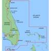
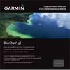
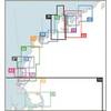
010-C0761-10 Bluechart G2 HEU002RDover to Amsterdam & England
Model: 010-C0761-10 Brand: Garmin
British coast: from Scarborough Harbour to Newhaven, including River Thames to London. Continental coast: from Amsterdam to Fecamp See your surroundings more clearly with BlueChart g2 data. With BlueChart g2, you'll get detailed marine cartography that provides convenient viewing of nautical content. BlueChart g2 allows you to see your vessel's precise, on-chart position in relation to naviads, coastal features, anchorages, obstructions, waterways, restricted areas and more. You will also have access to detailed mapping capabilities that include Safety Shading , Fishing Charts , smooth data transition between zoom levels, harmonious transition across chart borders, and reduction of chart discontinuities. « less
Product Specification
-
Universal Product Identifiers
Part Numbers: 010-C0761-10, 10804771, 35595GTIN: 00753759091453
Related Products
-
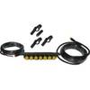
SIMKIT-2 Autopilot Install Kit
-
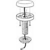
Rite 250 Manufacturing Marine T-Beam GPS Surface
-
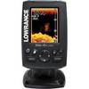
ELITE4X DSi Sonar
-
MapSource BlueChart - Jacksonville-Key West - Maps
-
010-C0732-20 Bluechart G2 HXUS031RSouthwest Caribbean microSD
-
WPC048; Champlain Canal Ed 1
-
Hydrographical Surveying; A Description of Means and Methods Employed in Constructing Marine Charts [Book]
-
Series 32 LED Navigation Lights Black Housing, Masthead
-
3964 40ft 24AWG CL2 Standard HDMI Cable - Black
-
Cat6a Ethernet Cable | 50ft | Orange | Network | 10 Gigabit
-
30RB 30 Amp - Ring (Blue)
-
YETP5E-7 7ft 24AWG Cat5e 350MHz UTP Bare Copper Ethernet Network Cable - Yellow