010-C0774-20 Bluechart G2 HXEU016RMediterranean Southeast
Model: 010-C0774-20 Brand: Garmin
See your surroundings more clearly with BlueChart g2 data. With BlueChart g2, you'll get detailed marine cartography that provides convenient viewing of nautical content. BlueChart g2 allows you to see your vessel's precise, on-chart position in relation to naviads, coastal features, anchorages, obstructions, waterways, restricted areas and more. You will also have access to detailed mapping capabilities that include Safety Shading, Fishing Charts, smooth data transition between zoom levels, harmonious transition across chart borders, and reduction of chart discontinuities. Covers: From Gulluk, Turkey east to include Cyprus, Syria, Lebanon and Israel, then west to Misratah, Libya. « less
Product Specification
-
Universal Product Identifiers
Part Numbers: 010-C0774-20, 10805083, 35622GTIN: 00753759091729
Related Products
-
NAVPILOT 720OB Autopilot for Outboard without Pumpset
-
Rite 250 Manufacturing Marine T-Beam GPS Surface
-
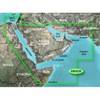
010-C0924-10 Bluechart G2 HAW005RThe Gulf & Red Sea Data Card
-
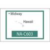
NT+ NA-C603F The Hawaiian Islands
-
1066 Replacement Lithium Battery for 2726 and 2727
-
Fastfind 210 - GPS Personal Locator Beacon, Lanyard Wrist Revere
-
50ft 24AWG Cat6 500mhz Crossover Ethernet Bare Copper Network Cable - Gray
-
1ft 24AWG Cat5e 350MHz UTP Bare Copper Ethernet Network Cable - Orange
-
Double Lens, 360� Navigation Lights, 120V Volts, Green
-
7ft 24AWG Cat6 550mhz UTP Ethernet Bare Copper Network Cable - Gray
-
5 Inch Power Mount Aft Lean for Universal Domes with Light Bracket Option PMA-5U-7L (PMA-57-M1 + ADA-R1) cpma5u7l
-
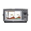
900 Series 931c DF - Fishfinder - included transducer : XHS-9-DB-74-T - dual-beam