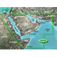
010-C0924-10 Bluechart G2 HAW005RThe Gulf & Red Sea Data Card
Model: 010-C0924-10 Brand: Garmin
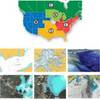
HAW005R Covers: Coverage of the Arabian Penninsula beginning at the Mediterranean Sea from Beirut to Alexandria. Coverage includes the Suez Canal, Gulf of Aqaba, and the Red Sea and Gulf of Aden in their entirety. Includes the Strait of Hormuz, Gulf of Oman, and coast of Somalia in the south. Coverage the of Kuwait, Saudi Arabia, Qatar, United Arab Emirates, along the southern coast of the Gulf and Iran along the northern coast. Coverage of Yemen and Oman coasts along the Indian Ocean to the Gulf of Oman, including Pakistan along the north coast, with general coverage of the Arabian Sea from Qamar Bay to the Delta of the Indus River. Included in this overall general coverage are numerous detailed charts covering areas such as Alexandria, Egy., Beirut, Leb., Al-Fuhaihil, Ad- Dammam, Bahrain, Ad-Dauha, and Abu Dhabi. Jiddah, Sau., Djibouti, Dji., and Aden, Yem. « less
Product Specification
-
Universal Product Identifiers
Part Numbers: 010-C0924-10, 35797GTIN: 00753759093273
Related Products
-
Training DVD f/Lowrance X47/X47EX/X51/X58DF N2329DVD
-
Radar Pole Mount 8' Kit for Raymarine 2KW and 4KW
-
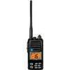
UM415BK Oceanus D Marine Radio (Black)
-
NT+ Wide Map, Ohio River: Cairo to Pittsburg NA-C039
-
37636 HotMaps Platinum Multi-Dimensional 3D Lake Maps
-
Hawkeye DF2200PX - Fishfinder - portable - included transducer
-
A65 Mfd USA Charts
-
Standard HX370S Hand Held VHF - HX370S
-
10ft USB A to Mini-B 5pin 28/28AWG Cable
-
P66-BL with Lowrance Blue Connector 50/200 D/S/T
-
80A Adapter-15/20A Str-20A Lockin
-
B260-BB 1kW Thru-Hull Transducer Standard 8-Pin Connector