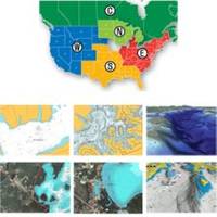
37361 HotMaps Platinum Multi-Dimensional 3D Lake Maps
Model: 37361 Brand: Navionics
HotMaps Platinum offers 300 of Navionics exclusive high-definition lake maps featuring 1 contours, 3D bottom view, top-down photo/map overlay, and panoramic lake pictures. HotMaps Platinum series also offers 14,000 additional lakes with underwater structure, improved accuracy, major roads, county lines and more. HotMaps Platinum is compatible with most new Humminbird, Lowrance, Northstar, and Raymarine chartplotters. Please call for chartplotter compatibility. « less
Product Specification
-
Universal Product Identifiers
Part Numbers: 11094216, 37361, 37631, CF-HMPT-S6, DEF-257887-CFSO6GTIN: 00821245125705
Related Products
-
Kenny Dorham - Show Boat [Audio CD]
-
T-940-4 8.4 Inch LCD Display 4KW 48NM Radar with 4.5' Open Array and 10 Meter Cable 33603
-
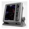
Mark 5x - Fishfinder - included transducer : Skimmer
-
Canadian Charts 3312 Jervis Inlet and / et Desolation Sound Chart
-
Baynes Sound Chart
-
Max Wide North America & South America C16996
-
Sea Charts of the British Isles: A Voyage of Discovery Around Britain & Ireland's Coastline [Book]
-
Mr F45-D Marine Digital Selective Calling Technology Fixed Mount VHF Radio - White
-
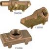
Ver. Pump Strainer f/1-1/4" Pipe 135806
-
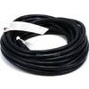
Cat6a Ethernet Cable | 5ft | Red | Network | 10 Gigabit
-
25ft 16AWG Power Cord Cable w/ 3 Conductor PC Power Connector Socket (C13/5-15P) - Black
-
6ft 28AWG VGA USB (A Type) to M1-D (pd) Cable - Black