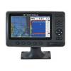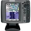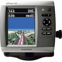
GPSMAP 546 - Marine GPS receiver - 5" color - 640 x 480
Model: 546 Brand: Garmin
The GPSMAP 546 is a compact chartplotter that features a high-resolution, super-bright 5" VGA color display along with an improved high-speed digital design for increased map drawing and panning speeds. It's ready to go with an easy-to-use interface and a built-in, satellite-enhanced basemap preloaded with all U. S. coastal areas, including Alaska and Hawaii as well as detailed charts for the Bahamas. The GPSMAP 546 also accepts BlueChart g2 Vision cards for added features and functionality such as high-resolution satellite imagery, 3-D views and Auto Guidance technology. « less
Product Specification
-
General
Product Type: GPS receiverRecommended Use: MarineCard Reader: SD Memory CardInterface: NMEA 0183, NMEA 2000Functions & Services: Tide TabCompatible Software: BlueChart g2 VisionFeatures: Depth sounder, XM weather supportFirst Seen On Google Shopping: February 2011 -
Display
Type: LCD - colorDiagonal Size: 5"Resolution: 640 x 480Features: Adjustable brightness -
Navigation
Waypoints: 3000Tracks: 50Tracklog Points: 20000Routes: 100Trip Computer: Sun/moon positions -
Miscellaneous
Design Features: Rugged caseProtection: WaterproofWaterproof Standard: IPX7Included Accessories: Protective cover, mounting bracket, power/data cable -
Dimensions & Weight
Width: 5.9 inDepth: 2.9 inHeight: 6.4 inWeight: 1.8 lbs -
Universal Product Identifiers
Part Numbers: 010-00774-00, 546GTIN: 00753759096151
Related Products
-
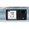
NAVPILOT 700OB Autopilot for Outboard without Pumpset
-
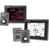
E22118 ST70 Plus Power Autopilot Keypad
-
8267; Map-Lake Oroville/San Luis
-
Chart Master Pro Combo - Internal Antenna U1-CHRT-PROI
-
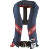
1230nav-00-000 Classic Seriesflotation Vest Nylon Univ Navy
-
Cat6a Ethernet Cable | 10ft | Green | Network | 10 Gigabit
-
VGA Male to Male Cable 50 ft. CL2
-
Cat6a Ethernet Cable | 15ft | White | Network | 10 Gigabit
-
F58685-2 - Connector , NLA Mercury Marine
-
Simnet/Nmea 2000 Adapter Cable c31832
-
Cat6a Ethernet Cable | 15ft | Black | Network | 10 Gigabit
-
700 Series 797c2 SI Combo NVB - Marine Chartplotter - 5" color - 640 x 480