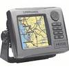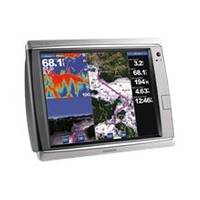
GPSMAP 7215 - Marine Chartplotter - 15" color - 1024 x 768
Model: 7215 Brand: Garmin
Put the power of Garmin's marine navigator right at your fingertips with the GPSMAP 7215. This touch screen chart plotter is the flagship in Garmin's line of full-featured marine products. The GPSMAP 7215 features with video-quality resolution on an impressive 15.5" XGA display. The GPSMAP 7215 also provides total system integration - allowing support for the addition of sonar, radar, weather and more. « less
Product Specification
-
General
Product Type: ChartplotterRecommended Use: MarineCard Reader: SD Memory CardInterface: NMEA 0183, NMEA 2000Functions & Services: Tide TabAntenna: ExternalFeatures: Alarm, XM Satellite Radio support, XM weather supportFirst Seen On Google Shopping: October 2011 -
Display
Type: LCD - color - touch screenDiagonal Size: 15"Resolution: 1024 x 768 -
Navigation
Waypoints: 5000Tracks: 50Tracklog Points: 50000Routes: 100Trip Computer: Sun/moon positions -
Connections
Interfaces: Garmin Marine Network -
Miscellaneous
Protection: WaterproofWaterproof Standard: IPX7Included Accessories: Protective cover, power cable -
Dimensions & Weight
Width: 15.5 inDepth: 5.9 inHeight: 11.9 inWeight: 17.4 lbs -
Universal Product Identifiers
Part Numbers: 010-00748-01, 7215GTIN: 00753759099381
Related Products
-
SP110RF-7 SP-110 System w/Rudder Feedback & Mechanical Remote D
-
HDS-5 Baja GPS 34274
-
GPS Backtrack Marine Locator Blue Clam Pack MODEL: 360070C
-
GSD 21 - GPS receiver remote sonar sensor
-
NA-C705 Furuno FP Format Banks Is BC Sumner Strait AK
-
NA-C702 C-Card Format Nanoose - Victoria Cap
-
Active Pass,Porlier Pass/et Montague Harbour Chart
-
Canadian Charts - N amp; O, Otter passage-bonilla Island Canadian
-
B16420Cx 1kW 50200khz 20 Deg Tilted Element
-
SP-X Speed Probe X-Series Connector wspx
-
Flush Mount Utility Light 401515-1 Screw Mount
-
LHR-80 VHF/GPS Handheld Marine Radio, LHR80,22-17