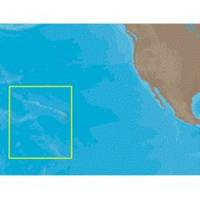
NA-C603 C-Card Format Hawaiian Islands
Model: NA-C603 Brand: C-Map
Every single chart is included for the area covered (at all scales), as well as all the new Value-Added Data (coastal mapping, aerial photos, etc.). MegaWide cartridges can only be used on MAX compatible plotters. C-Card Compatability Check with C-Map for list of compatible models Cobra Interphase Koden Navman Northstar Simrad Si-Tex Standard Horizon NA-C603 Hawaiian Islands NT+ Cartography NT+ electronic charts feature much wider coverage areas at substantially lower prices. « less
Product Specification
-
Universal Product Identifiers
Part Numbers: 19571, CMANAC603CCARD, CW-19571, NA-C603C-CARD
Related Products
-
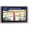
n�vi 1350T - Hiking, automotive GPS receiver - 4.3" color - 480 x 272 - widescreen
-
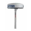
SC103 Radar Pole Mount 6' Kit for Garmin/Furuno Domes
-
Hydrographical Surveying; A Description of Means and Methods Employed in Constructing Marine Charts [Book]
-
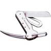
1551 Rigging Knife Deluxe
-
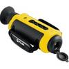
432-0004-01-00S First Mate Handheld Thermal Imager
-
Series 50 Classic Stainless Steel Navigation Lights
-
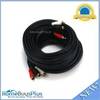
202234 50ft S-Video & 50ft RCA Audio Cable - Molded
-
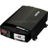
Br Wholesale RV & Marine 806-1206 Prowatt Sw 600 Inverter
-
Marine Cowl Vent w/Hose Adapter F/3 BEC-C7
-
SP-X Speed Probe X-Series Connector wspx
-
MPI 480-6000 6 in. Insulated Air Conditioner Duct
-
GPSMAP 478 - Marine GPS receiver - 3.8" color - 480 x 320