Scotty, Chartplotters
-
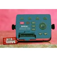
EXPLORER PLUS C-MAP MAX/NT+Charting System Control Unit
- Turns any "off-the-shelf" VGA Monitor into full function Electronic Charting System.- Available with or without 16 Ch. GPS/WAAS receiver.cmaopDescriptionThe EXPLORER PLUS turns almost any "off the shelf" PC monitor into a full-featured C-MAP electronic charting system. Couple this unique product to an existing onboard monitor or add just about any size CRT or flat panel display for a very convenient two piece charting system with unlimited mounting possibilities. Compact controller unit connects to most standard monitor with VGA input. Straightforward logic and soft key operating system offers uncanny ease of operation. Waterproof trackpad provides smooth cursor transitions to plot, scroll, pan and make menu selections. Compatible with the new C-MAP MAX charts, technically the most innovative C-MAP charts ever designed. Dual slot C-MAP MAX/NT+ cartridge doubles the charting capability. A unique programmable anti-grounding feature using 14Guardian!22 Grounding Alarm* 14provides alarms if your current course takes you within danger of shoals, obstacles or other areas where the water is too shallow for your vessel's draft. This feature helps provide an added level of security for all boaters. Available with or without GPS/WAAS sensor and with external GPS/Loran receiver for True Loran Positioning as model Explorer PlusL. Perfect for use with the optional SI-TEX GPS-20 model sensor. Position displayed when connected to GPS. Expands to an all-in-one GPS Charting System/Fishfinder/Radar with optional ES502 Fishfinder Module and optional 2kW to 4kW MDS Radar Sensors. Displays tidal data and port service information for selective areas worldwide from local C-Card. Up to 1000 Waypoints, Mark or Events and 5000 points per track. Control unit can be mounted up to 6 feet away from display unit, multiplying the mounting options on any vessel. In addition to charting information, EXPLORER PLUS numerically indicates speed, course, distance, arrival time, STG, temp and depth when interfaced with proper sensors. Charting is displayed in North-up or Course-up modes with GPS input. Controller unit is designed to be either tabletop, bulkhead or flush mounted. Special trunion bracket and mounting knobs are provided for easy installation and removal. NMEA-0183 data port for interfacing with other onboard electronics. Optional memory cards provide unlimited track and waypoint storage capability.
-
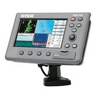
NEW! SNS-700 7 1D HD WVGA Color LCD
DescriptionHigh Definition Daylight Viewable DisplayPlenty of room for split-screen displays of chart, sounder and radar. Uses C-MAP MAX on SD Choice of internal or external GPS antenna Flush mount or quick disconnect IP67 waterproof rating Available with built-in 600W dual-frequency sounder Integrates with MDS Radar Sensor, Metadata AIS Modules.Also available as EC-7
-
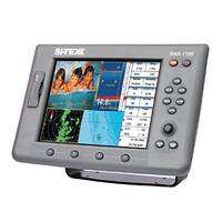
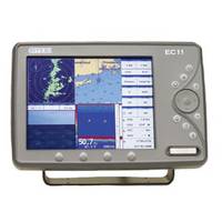
SNS-1100 10.4 1D HD SVGA Color LCD
DescriptionSerious multi-function performance for larger vessels. Uses C-MAP MAX on SD Includes external GPS/WAAS Antenna IP67 waterproof rating 2 Video Inputs/1 Video Output Connects with 600W dual-frequency Black Box sounder Integrates with MDS Radar Sensor, Metadata AIS ModulesAlso available as EC-11
-
-
SVS-760C Digital Chartplotter
DescriptionThe SVS-760CF is an extremely powerful chartplotter, offering the ability to run both types of cartography in the same machine, enabling boaters to select the platform that works best for their region, personal preference and specific boating needs on any given voyage. This machine also provides Navionics Sonar Chart Bathymetric recording capability, allowing boaters to survey their own areas and have this data added to the Navionics Sonar Chart Database. The unit is also Navionics Community Layer capable, allowing users to download the latest information for their chart area.The SVS-760C offers tremendous memory, with storage for 20,000 marks/waypoints, 100 routes and 50,000 track points. It is also designed for easy integration with SI-TEX 19s Metadata AIS module (or other AIS receivers) for enhanced situational awareness and safety at sea.All this technology is contained in a rugged, compact IPX-7 waterproof case that can be mounted indoors or out, on any style or size of boat.
-
EC11 10.4 HD SVGA Color LCD
- Two composite video inputs- VGA video output- Bracket/flush mount- Available with external GPS antenna- 10,000 waypoints/marks- 50 routes of 50 waypoints each- 10,000 trackpoints- High resolution 800 x 600 display- Works with optional MDS Radar Sensor- Waterproof to IP67 standardec111DescriptionEC11 10.4 HD SVGA Color LCD Two video inputs to connect optional cameras Video output for second-station repeater capability Bracket/flush mount Specifications subject to change without notice. Standard EC Series features: Ultra-fast processor provides instant screen changes Expands to all-in-one unit with optional Fishfinder, Radar, AIS senors (Not: Radar Sensor option not available on EC5) Included GPS/WAAS reciever Use C-MAP Max SD-Cards Rotary/Track dial, backlit keys and on-screen menus for easy access to all system functions Interfaces with option DSC VHF to recieve and display position info of other vessels equipped with DSC transceiver within range Guardian!22 Programmable Anti-Grounding feature Depth Graph feature Split-screen displays SD reader North-up or Track-up modes Built-in worldwide background chart Port Info, Find Function, Tide Info GOTO and MOB functions Selectable languages Coordinates displayed in Lat/Lon, TD's, UTM or OSGB NMEA 0183 dataport for interfacing data with other on-board electronics IP67 Waterproof rating
-
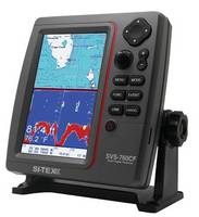
SVS-760CF Chartplotter/Sounder Combo
DescriptionThe versitile SVS-760CF is a combination digital echo sounder and chartplotter with built-in 50-channel GPS receiver capable of running both C-MAP MAX and Navionics Gold cartography.The 50/200kHz SVS-760 sounder features powerful 600W output and a vertically oriented, sunlight viewable 7.5 1D color LCD display that optimizes presentation of bottom composition/contour and fish targets beneath the vessel. With depth ranges down to 4,800 feet, a high-resolution color LCD display, clearly marked controls and large, easy-to-use controls, this sounder is ideal for professional users as well as serious sportfishing duty.SI-TEX 19s digital sounding technology eliminates unwanted noise and provides a sharp image of the seabed and fish targets. The unit 19s high-speed CPU delivers seamless zooming and provides superior readings even at higher boat speeds. This powerful processor also ensures that even the smallest fish targets are presented on the display. Among the SVS-760CF 19s long list of professional sounder features are White Line/Black Line Bottom Discriminator to separate bottom-hugging fish from the sea floor, Auto/Manual Gain and Range Selection, Bottom Lock, Bottom Zoom and A-Scope. Users can select from various fish symbols based on the size and type of targets being marked.For enhanced operation and awareness, alarms are provided for Depth, Fish School and Water Temperature. The SVS-760CF also features an SD card slot, allowing fishermen to back up information and record data on important fishing spots.The SVS-760CF delivers all this fishfinding performance with the added capabilities of a powerful chartplotter. The ability to run both types of cartography in the same machine allows boaters to select the platform that works best for their region, personal preference and specific boating needs on any given voyage. This machine also provides Navionics Sonar Chart Bathymetric recording capability, allowing boaters to survey their own areas and have this data added to the Navionics Sonar Chart Database. The unit is also Navionics Community Layer capable, allowing users to download the latest information for their chart area.The SVS-760CF offers tremendous memory, with storage for 20,000 marks/waypoints, 100 routes and 50,000 track points. It is also designed for easy integration with SI-TEX 19s Metadata AIS module (or other AIS receivers) for enhanced situational awareness and safety at sea.All this technology is contained in a rugged, compact IPX-7 waterproof case that can be mounted indoors or out, on any style or size of boat.
-
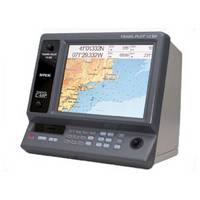
TRAWL PLOT 12SD 12.1" Color LCD 16 Ch. GPS/WAAS Charting System
Designed for the professional- One-Touch event mark for easy storage & retrieval of gear marks.- Stores up to 5000 waypoints/marks, 50 routes and 50,000 track points- Unlimited storage of track/route data on SD memory cards- Works with optional MDS Radar SensortrawlDescriptionAdvanced C-MAP MAX/NT+ Charting System for the Professional features High-speed Intel Xscale Processor, Easy Operation, Unlimited Storage, GPS WAAS Positioning, Large 12.1" Daylight Viewable Display and expands to an all-in-one GPS Chart/Fishfinder/Radar with optional sensors. 12.1" XVGA Color LCD TFT display with 800 x 600 pixels for high-definition. External GPS/WAAS receiver will put your boat within 3 meters of your waypoint in most situations. Available with external GPS/Loran receiver for True Loran Positioning as model TrawlPlot 12SDL. Newly designed high-speed processor with INTEL XSCALE Architecture gives you instant screen changes. Zoom level changes appear in the blink of an eye, regardless of the amount of screen detail. Compatible with the new C-MAP MAX charts, technically the most innovative C-MAP charts ever designed. System operates as a C-MAP MAX based chart plotter with four C-Card slots, or as a track plotter without map display. Guardian!22 Programmable Anti-Grounding feature* lets you know if your current course takes you within preset distance of charted shoals, obstructions or other areas where the water is too shallow for your vessel's draft. Expands to an all-in-one GPS Charting System/Fishfinder/Radar with optional ES502 Fishfinder Module and optional 2kW to 4kW MDS Radar Sensors. Depth Graph feature accepts input from onboard sounder or optional Active Transducer to display graphic presentation of vessel's current depth and recent depth history. Operates in North-Up or Track-Up modes. Coordinates displayed in Lat/Lon, Loran TD's, or UTM. Displays Loran TD's even when position data is supplied in Lat/Lon coordinates. Alphanumeric designations for easy identification of waypoints and marks. "One-Touch" event mark 14for easy storage and retrieval of gear marks. Unlimited storage of track and route data on optional SD (secure digital) memory cards. Each disk can store up to 80,000 track plots and up to 40,000 user points of track and route data for quick recall and display as desired. Tide Info feature uses local C-Card information to calculate tide graph for local ports. Find Function uses local C-Card to locate nearest boatyard, bank, even the closest shower. Joystick control of on-screen cursor to plot, scroll, pan, zoom and place waypoints, events and marks, and to control on-screen VRM and EBL. GOTO and MOB functions. Fourteen selectable languages. Route Data Page displays waypoint position, distance and bearing between the previous waypoint and the current one, fuel consumption, fuel consumption between the waypoint and the first waypoint of the route, estimated time enroute, and total distance. Data information window displays digital route navigation data, and a wealth of other information. Two NMEA-0183 dataports for interfacing data with other on-board electronics. Zoom into as little as 180' across screen. Optional ES502 Fishfinder Module adds full-featured fishfinder capabilities.