010-C0752-10 Bluechart G2 HAF452SKnysna Sa to Beira MZ Data
Model: 010-C0752-10 Brand: Garmin
Coverage of the southeastern coast of Africa from Mossel Bay, S. Af. to the mouth of the Zambezi River. Detailed coverage includes Port Elizabeth and Durban, S. Af., Maputo, Moz., as well as the Prince Edward Islands. See your surroundings more clearly with BlueChart g2 data. With BlueChart g2, you'll get detailed marine cartography that provides convenient viewing of nautical content. BlueChart g2 allows you to see your vessel's precise, on-chart position in relation to naviads, coastal features, anchorages, obstructions, waterways, restricted areas and more. You will also have access to detailed mapping capabilities that include Safety Shading , Fishing Charts , smooth data transition between zoom levels, harmonious transition across chart borders, and reduction of chart discontinuities. « less
Product Specification
-
Universal Product Identifiers
Part Numbers: 010-C0752-10, 10804656, 35585GTIN: 00753759089733
Related Products
-
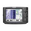
1100 Series 1197c SI Combo CHO - Marine Chartplotter - 10.4" color - 800 x 600
-
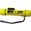
LPS - 1 Hand - Held Digital Sonar Depth Finder
-
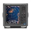
1835 10.4" Color LCD Radar 24" 4KW Dome
-
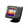
Elite 5x - Fishfinder - included transducer : Skimmer
-
SC111 PowerTower Starboard Mounted Bar for Light, GPS, VHF
-
BlueChart g2 Vision - Aegean Sea and Sea of Marmara - Maps
-
010-00756-00 VHF 300 Marine Radio
-
LTD ZDIGAIS100 USB AIS Receiver
-
80A Adapter-15/20A Str-20A Lockin
-
A3030Y30W Y Adapter - 2 30 Amp 125VAC Connectors -to- 1
-
GPSMAP 420s - Marine GPS receiver - 4" color - 240 x 320
-
GPS 72 - Marine, hiking GPS receiver - Monochrome - 120 x 160