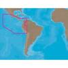
010-C0764-10 Bluechart G2 HEU005RIreland West Coast Data Card
Model: 010-C0764-10 Brand: Garmin
Detailed coverage of the west coast of Ireland from Cork Harbour to Belfast. Also covers the Scottish coast from the Isle of Colonsay to Campbeltown Harbour. See your surroundings more clearly with BlueChart g2 data. With BlueChart g2, you'll get detailed marine cartography that provides convenient viewing of nautical content. BlueChart g2 allows you to see your vessel's precise, on-chart position in relation to naviads, coastal features, anchorages, obstructions, waterways, restricted areas and more. You will also have access to detailed mapping capabilities that include Safety Shading , Fishing Charts , smooth data transition between zoom levels, harmonious transition across chart borders, and reduction of chart discontinuities. « less
Product Specification
-
Universal Product Identifiers
Part Numbers: 010-C0764-10, 10804854, 35601GTIN: 00753759091514
Related Products
-
Remote Mount Autopilot Drives for Cable Steering 29010009
-
Magnifier Chart Weight, Brass
-
SA-C001 Furuno FP Format - Peru, P. Vallarta, P. Bolivar
-
Howe Sound Chart
-
0065DP4PLB 1/2 Scoop Thru Hull w/Nut
-
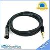
6ft Premier Series XLR Male to 1/4inch TRS Male 16AWG Cable (Gold Plated)
-
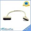
743 HPDB50 M/CN50 M SCSI Cable , 25pr - 1.5ft
-
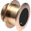
B175-12-M Broadband CHIRP, No CONNECTOR, Depth & Temperature Thru-Hull Tilted
-
1ft 24AWG Cat6 550mhz UTP Ethernet Bare Copper Network Cable - Gray
-
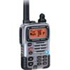
HX471 VHF Radio, 5W Submersible Tri Band HH Silver
-
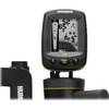
Fishin' Buddy 130 - Fishfinder - portable - included transducer - single-beam
-
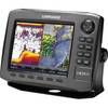
000-10537-001 HDS-8 Gen2 Insight USA 83200khz Marine Electronics