0100077300 Gpsmap536 Plotter
Model: Gpsmap536 Brand: Garmin
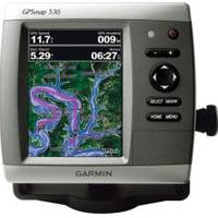
Mfr: Garmin - 100077300; These compact GPS/Chartplotters feature an ultra-bright 5" diagonal color display with a high-speed digital design for faster map drawing and panning speeds. Includes a built-in basemap and an easy-to-use interface to help navigate your waters with ease. Accepts BlueChart g2 Vision cards for added features and functionality like high-resolution satellite imagery, 3-D views, and Auto Guidance Technology. 10-32V DC. Other features include AIS support, DSC position display, audible alarms, tide tables, sun & moon informations, NMEA interface, and more. Standard models are GPS/Chartplotters and do not include fishfinding capabilities. Inland Lake maps. 546/546s include the basemap plus U.S. Coastal maps, including Alaska & Hawaii, as well as detailed Bahamas charts. Transducers for S models sold separately. « less
Product Specification
-
Universal Product Identifiers
Part Number: 100077300
Related Products
-
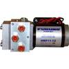
PUMPHRP11-12 1.1 Cubic Inch/Second Pump - 12V
-
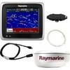
A67 5.7 Multifunction Radar Pack WE70077E92130A55077dA6236
-
CF/648P+ Platinum Plus Lake Ontario on CF
-
TXOKC1 LakeMaster Map Texas/Oklahoma Electronic Char
-
The nautical chart [Book]
-
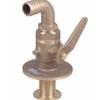
Bronze Seacock, 3/4 Inch Adapter, 90 Degree 0834005PLB
-
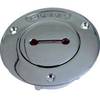
Deck Plates, Fills for Pipe, 1", Unmarked, Bronze
-
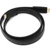
3ft 24AWG CL2 Flat High Speed HDMI Cable - Black
-
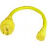
LTD A1530S 15 to 30 Amp 125v/125v Straight Adapter
-
/ Quicksilver 22-64294 Connector
-
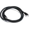
5ft 24AWG Cat5e 350MHz UTP Ethernet Bare Copper Network 3375
-
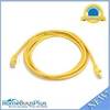
YETP5E-7 7ft 24AWG Cat5e 350MHz UTP Bare Copper Ethernet Network Cable - Yellow