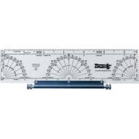
120 Marine Navigation Parallel Plotter
Model: 120 Brand: Weems And Plath
Our most popular plotter! This instrument consists of a plotter mounted on a roller. The plotter contains distance scales at 1:20 000 1:40 000 and 1:80 000 to fit the N.O.S. Coast and Harbor Charts as well as an inch scale. Included are a semi-circular protractor for measuring courses and bearings against a meridian on the chart and two quarter circle protractors for measuring courses and bearings against a parallel of latitude. Courses and parallel lines are transferred and kept parallel by means of two rollers which are mounted on a slide axis. Used for measuring or laying off courses and distances on a nautical chart. Instructions included. Dims: 3.5 x 12.5 . « less
Product Specification
-
Universal Product Identifiers
Part Numbers: 120, DEF-803231GTIN: 00721002001207
Related Products
-
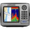
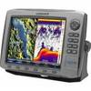
HDS-5 Lake Insight Multifunction w/o Trans 34242
-
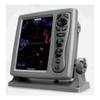
CH250BB/88/325 88 kHz Black Box Searchlight Sonar System. Includes 250mm Travel Hoist and Operates at 24 & 32VDC
-
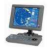
T-940-4 8.4 Inch LCD Display 4KW 48NM Radar with 4.5' Open Array and 10 Meter Cable 33603
-
JMA-5106 Black Box Radar 72NM, 6KW with 4 Foot Open Array without Display
-
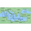
MapSource BlueChart - Italy, Adriatic Sea - Maps
-
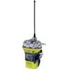
ACR Globalfix Pro 406 EPIRB Integral GPS - Category 2
-
0493010PLB 2-1/2" IPS Intake Strainer Bronze
-
4KW 24in Radome No Cable E52080
-
42991 HDS-10 Gen2 Insight USA w/o XD
-
50ft 24AWG Cat5e 350MHz UTP Bare Copper Ethernet Network Cable - White
-
Patch cable - CAT 6 - RJ-45 - M - Unshielded twisted pair (UTP) 14 ft - Gray
-
F-Splice-CP/GH-01 Connector for RG-6U Cable