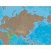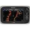
37361 HotMaps Platinum Multi-Dimensional 3D Lake Maps
Model: 37361 Brand: Navionics
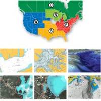
HotMaps Platinum offers 300 of Navionics exclusive high-definition lake maps featuring 1 contours, 3D bottom view, top-down photo/map overlay, and panoramic lake pictures. HotMaps Platinum series also offers 14,000 additional lakes with underwater structure, improved accuracy, major roads, county lines and more. HotMaps Platinum is compatible with most new Humminbird, Lowrance, Northstar, and Raymarine chartplotters. Please call for chartplotter compatibility. « less
Product Specification
-
Universal Product Identifiers
Part Numbers: 11094216, 37361, 37631, CF-HMPT-S6, DEF-257887-CFSO6GTIN: 00821245125705
Related Products
-
M81136 T2 Rotary Drive 12V
-
HDS-10 No Transducer - 140-41
-
Tx25s-1 25KW Open Array Radar with 7' Antenna
-
ME-C202 C-Card Format - Red Sea - Arabian Sea
-
2846.0 Globalfix iPro 406 MHz GPS EPIRB - Category 1
-
061 15 Parallel Rules
-
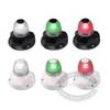
Marine Naviled 360 All-Round Navigation Light
-
10/3 30 Amp Cable, 250' Spool, Yellow 14179
-
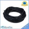
Ethernet Category 6 Enhanced RJ45 Network Patch Cable - 50' Black.
-
Micro Cable 1 Meter
-
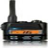
Standard HX370SAS I.S. VHF
-
E62355 - e7D, 7 GPS/MFD/Sonar w/o Charts