ChartKit Book w/Companion CD - Florida East Coast & Map
Model: Brand: Maptech
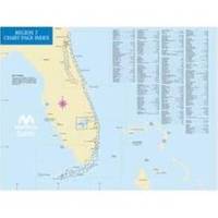
Mary's Entrance to Dry Tortugas, inside and outside, including St. Johns River, St. Lucie River and Lake Okeechobee. Full-color charts, waypoints, courses and distances, chart datums for GPS, Yeoman points, and aerial photos. 22 X 17, 78 chart pages. Product Overview Used by generations of boaters, ChartKits are full-color reproductions of U.S. government and private charts spiral bound into popular cruising regions. The convenient-sized books are large enough to allow for manual plotting, yet small enough to sit on your nav-station or lap GPS Ready New features make ChartKits easy to use with your GPS. Most charts include one-minute lat./long. Grids to make vessel positioning a breeze, and major navigation aids are identified with named GPS waypoints. Small and Large Scale Charts ChartKits include small-scale, wide « less
Product Specification
-
Universal Product Identifiers
Part Number: PAPREGION07
Related Products
-
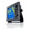
JMA-3340HS Radar 10KW 72 nm, 4 ft Open Array with 27-48 rpm Radar Antenna
-
Chrome Chart Light Large Head 20W 400545
-
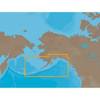
NA-C802 Furuno FP Format Gulf of Alaska
-
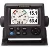
RD33 4. 3 in. Color LCD Navigational Data Organizer
-
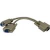
04-1092-000R Standard VGA Cable Splitter
-
10ft Premium 2.5mm Stereo Male to 2rca Male 22AWG Cable 5607
-
500ft 14AWG CL2 Rated 2-Conductor Loud Speaker Cable (for In-Wall Installation)
-
743 HPDB50 M/CN50 M SCSI Cable , 25pr - 1.5ft
-
10 ft DVI cable - dual link DVI - male - PC
-
DA645G Mini-UHF Adapter
-
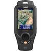
ONIX400 - Hiking GPS receiver - 3.5" color - 320 x 240
-
GPS-90 18-Channel GPS Satellite WAAS Receiver