Chartmaster 169CS (u1-Chrt-169i)
Model: 169CS Brand: Interphase Technologies
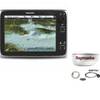
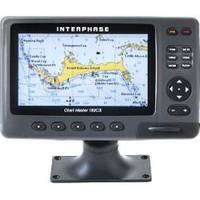
New Page 1 Chart Master 169CS The Chart Master 169CS is designed for versatility and easy integration into a full bridge system, with two serial ports and an advanced USB for connection to autopilots or a variety of other NMEA devices. C-MAP? s Ports and Tides? The Chart Master 169CS will accept depth information from a "Smart Transducer" or other NMEA source and show a split screen view of graphical depth information. Full and Split Screen Chart Display. Shows position of boat and course and distance to selected waypoints. Status Screen shows all satellites being received and their relative signal strength. Helps to easily determine if unit is acquiring satellites. « less
Product Specification
-
Universal Product Identifiers
Part Number: U1-CHRT-169I
Related Products
-
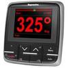
E22166 P70 Autopilot Control Head
-
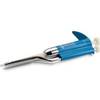
hi731340 200 L Graduated Pipette
-
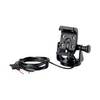
GPS receiver marine mount bracket
-
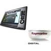
Package(E140W, GPS Antenna, 4KW 18 Inch Digital Radome & Radar Cable )
-
Package(c125 with USA Coastal Chart, 4KW 18 Inch Digital Radome & Radar Cable)
-
Tiller Autopilot St-1000+ A12004
-
GPS 152 - Marine GPS receiver - 4" monochrome - 100 x 160
-
Ram 1.5" Connector
-
TM00701 Power Connector Plastic
-
Power Heavy Duty Docking Replacement Light Only, Black, 12V
-
5 Inch Power Mount with Light Mount Bracket Option PMF-5F-7L (PMF-57-M1 + ADA-R1) cpmf5f
-
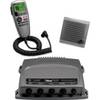
VHF 300 AIS VHF Radio with AIS Receiver